• 中国中文核心期刊
  • 中国科学引文数据库(CSCD)核心库来源期刊
  • 中国科技论文统计源期刊(CJCR)
  • 第二届国家期刊奖提名奖
Volume 33 Issue 2
Apr.  2020
Article Contents
Turn off MathJax

Citation:

Dynamics of Groundwater Level and Its Affecting Factors under Different Wetland Vegetation of Lixiahe Plain, Jiangsu Province

  • Corresponding author: WANG Lei, wl.stone@163.com
  • Received Date: 2019-04-28
    Accepted Date: 2019-10-20
  • Objective To understand the dynamic characteristics of groundwater level in typical freshwater wetland vegetation in the Lixiahe Plain which is rich in water resources in Jiangsu Province. Method Two groundwater depth monitoring wells were set respectively in two typical freshwater wetland vegetations (Taxodium ascendens coniferous forest and Poplar broadleaved forest) in Lixiahe Plain of Jiangsu province. The monthly and seasonal variation of groundwater level were analyzed based on the long-term observation data of groundwater level. In addition, the temperature and precipitation data of the forests during the hydrological year from September 2016 to August 2017 were also collected. The correlations between the dynamics of groundwater level and the variation of temperature and precipitation were analyzed. Result There were significant differences in the dynamics of groundwater level between the two freshwater wetland vegetations. T. ascendens forest was almost flooded all the year round, and its monthly mean groundwater level was higher than that of Poplar forest. The amplitude of monthly variation of groundwater level in Poplar forest was larger than that of T. ascendens forest, and it showed a seasonal variation. On the seasonal scale, the average groundwater level in T. ascendens forest and Poplar forest in summer was significantly lower than that in other seasons. The effects of precipitation on the variation of groundwater level of the two freshwater wetland vegetations were different. The change of groundwater level in Poplar forest lagged behind the amount of precipitation about one month, while this lag did not appear in T. ascendens forest. The average monthly groundwater level was negatively correlated with the mean monthly temperature in both vegetation types. Conclusion It is concluded that there are differences in the dynamics of groundwater level and the influencing factors between the two types of freshwater wetland vegetation. In Lixiahe Plain with abundant water resources, temperature rather than the precipitation is the key factor affecting the change of groundwater level in the freshwater wetland vegetation.
  • 加载中
  • [1]

    Johansen O M, Andersen D K, Ejrnæs R, et al. Relations between vegetation and water level in groundwater dependent terrestrial ecosystems (GWDTEs)[J]. Limnologica, 2017, 68(1): 130-141.
    [2]

    Zhu L, Gong H, Dai Z, et al. An integrated assessment of the impact of precipitation and groundwater on vegetation growth in arid and semiarid areas[J]. Environmental Earth Sciences, 2015, 74(6): 5009-5021. doi: 10.1007/s12665-015-4513-5
    [3] 贺芳芳, 戴怀林, 陈风喜. 上海市郊林带区与非林带区地下水水位及地表径流变化对比分析[J]. 中国生态农业学报, 2008, 16(3):707-711.

    [4] 韩 路, 王海珍, 牛建龙, 等. 荒漠河岸林胡杨群落特征对地下水水位梯度的响应[J]. 生态学报, 2017, 37(20):6836-6846.

    [5] 陈 婕, 徐 庆, 高德强, 等. 西鄂尔多斯半日花及霸王的水分利用[J]. 林业科学研究, 2016, 52(2):47-56.

    [6]

    Seeyan S, Merkel B J, Abo R K, et al. Investigation of the Relationship between Groundwater Level Fluctuation and Vegetation Cover by using NDVI for Shaqlawa Basin, Kurdistan Region – Iraq[J]. Journal of Geography and Geology, 2014, 6(3): 187-202.
    [7] 赵新风, 李伯岭, 王 炜, 等. 极端干旱区8个绿洲防护林地土壤水盐分布特征及其与地下水关系[J]. 水土保持学报, 2010, 24(3):75-79.

    [8] 高德强, 张蓓蓓, 徐 庆, 等. 氢氧稳定同位素在淡水湿地森林水文过程研究中的应用[J]. 世界林业研究, 2017, 30(2):20-25.

    [9] 叶正伟, 许有鹏, 潘光波. 江淮下游降水特征及其对水位的影响研究——以里下河腹部地区为例[J]. 自然资源学报, 2013, 28(11):1922-1934. doi: 10.11849/zrzyxb.2013.11.009

    [10] 李连庆, 曹文元, 王玉龙, 等. 里下河低湿地适生树种调查及造林技术初步研究[J]. 江苏林业科技, 2012, 39(2):33-36. doi: 10.3969/j.issn.1001-7380.2012.02.007

    [11]

    Stasik R, Korytowski M. Analysis of groundwater level changes in clearcutting area of chosen forest habitats[J]. Journal of Ecological Engineering, 2015, 16(4): 59-64.
    [12]

    Csafordi P, Szabo A, Balog K, et al. Factors controlling the daily change in groundwater level during the growing season on the Great Hungarian Plain: a statistical approach[J]. Environmental Earth Sciences, 2017, 76(20): 675. doi: 10.1007/s12665-017-7002-1
    [13] 黄金廷, 尹立河, 董佳秋, 等. 毛乌素沙地地下水浅埋区沙柳蒸腾对降水的响应[J]. 西北农林科技大学学报, 2013, 41(11):217-222.

    [14]

    Hirano T, Kusin K, Limin S, et al. Evapotranspiration of tropical peat swamp forests[J]. Global Change Biology, 2015, 21(5): 1914-1927. doi: 10.1111/gcb.12653
    [15] 李 雪, 叶思源, 宋 凡, 等. 京津冀平原区地下水水位变化主导因素的定量识别研究[J]. 水文, 2018, 38(1):21-27. doi: 10.3969/j.issn.1000-0852.2018.01.004

    [16] 李 琦. 渭河流域地下水对气候变化的响应研究[D].西安: 长安大学, 2015.

    [17] 贾瑞亮, 周金龙, 李 巧. 我国气候变化对地下水资源影响研究的主要进展[J]. 地下水, 2012, 34(1):1-4. doi: 10.3969/j.issn.1004-1184.2012.01.01t

    [18] 高德强, 徐 庆, 张蓓蓓, 等. 鼎湖山大气降水氢氧同位素特征及水汽来源[J]. 林业科学研究, 2017, 30(3):384-391.

    [19] 马迎宾, 徐 庆, 高德强, 等. 汤浦水库湿地森林区大气降水氢氧同位素特征及水汽来源[J]. 林业科学研究, 2018, 31(3):37-44.

    [20] 张 林, 王春景. 清苑县降雨量变化对地下水水位的影响分析[J]. 地下水, 2016, 38(3):66-67.

    [21]

    Faridatul M I. A comparative study on precipitation and groundwater level interaction in the highly urbanized area and its periphery[J]. Current Urban Studies, 2018, 6(2): 209-222. doi: 10.4236/cus.2018.62012
    [22] 于致龙, 韩 辉, 宋 鸽. 章古台地下水水位与降水量变化动态相关性分析[J]. 防护林科技, 2018(3):26-29.

    [23] 幺 文, 吴淑梅. 地下水位与降水量的变化规律及其影响[J]. 内蒙古科技与经济, 2017(13):51-52. doi: 10.3969/j.issn.1007-6921.2017.13.026

    [24]

    Mercau J L, Nosetto M D, Bert F, et al. Shallow groundwater dynamics in the Pampas: Climate, landscape and crop choice effects[J]. Agricultural Water Management, 2016, 163(1): 159-168.
    [25]

    Chen Z, Grasby S E, Osadetz K G, et al. Relation between climate variability and groundwater levels in the upper carbonate aquifer, southern Manitoba, Canada[J]. Journal of Hydrology, 2004, 290(1): 43-62.
    [26] 马雄德, 范立民, 严 戈, 等. 植被对矿区地下水水位变化响应研究[J]. 煤炭学报, 2017, 42(1):44-49.

    [27] 王 平, 于静洁, 闵雷雷, 等. 额济纳绿洲浅层地下水动态监测研究及其进展[J]. 第四纪研究, 2014, 34(5):982-993. doi: 10.3969/j.issn.1001-7410.2014.05.08

  • 加载中
通讯作者: 陈斌, bchen63@163.com
  • 1. 

    沈阳化工大学材料科学与工程学院 沈阳 110142

  1. 本站搜索
  2. 百度学术搜索
  3. 万方数据库搜索
  4. CNKI搜索

Figures(6)

Article views(3788) PDF downloads(36) Cited by()

Proportional views

Dynamics of Groundwater Level and Its Affecting Factors under Different Wetland Vegetation of Lixiahe Plain, Jiangsu Province

    Corresponding author: WANG Lei, wl.stone@163.com
  • 1. Jiangsu Academy of Forestry, Nanjing 211153, Jiangsu, China
  • 2. Research Institute of Forest Ecology, Environment and Protection, Chinese Academy of Forestry Beijing 100091, China

Abstract:  Objective To understand the dynamic characteristics of groundwater level in typical freshwater wetland vegetation in the Lixiahe Plain which is rich in water resources in Jiangsu Province. Method Two groundwater depth monitoring wells were set respectively in two typical freshwater wetland vegetations (Taxodium ascendens coniferous forest and Poplar broadleaved forest) in Lixiahe Plain of Jiangsu province. The monthly and seasonal variation of groundwater level were analyzed based on the long-term observation data of groundwater level. In addition, the temperature and precipitation data of the forests during the hydrological year from September 2016 to August 2017 were also collected. The correlations between the dynamics of groundwater level and the variation of temperature and precipitation were analyzed. Result There were significant differences in the dynamics of groundwater level between the two freshwater wetland vegetations. T. ascendens forest was almost flooded all the year round, and its monthly mean groundwater level was higher than that of Poplar forest. The amplitude of monthly variation of groundwater level in Poplar forest was larger than that of T. ascendens forest, and it showed a seasonal variation. On the seasonal scale, the average groundwater level in T. ascendens forest and Poplar forest in summer was significantly lower than that in other seasons. The effects of precipitation on the variation of groundwater level of the two freshwater wetland vegetations were different. The change of groundwater level in Poplar forest lagged behind the amount of precipitation about one month, while this lag did not appear in T. ascendens forest. The average monthly groundwater level was negatively correlated with the mean monthly temperature in both vegetation types. Conclusion It is concluded that there are differences in the dynamics of groundwater level and the influencing factors between the two types of freshwater wetland vegetation. In Lixiahe Plain with abundant water resources, temperature rather than the precipitation is the key factor affecting the change of groundwater level in the freshwater wetland vegetation.

  • 森林植被与地下水之间有着复杂的相互关系。地下水水位变化影响森林群落结构组成与生长状况,从而影响到整个森林生态系统的稳定性[1-2]。同时,森林植被可通过其林冠层对降水的截留作用以及森林土壤对水源的涵养作用,对地下水水位进行调节[3-4]。在干旱或半干旱地区,水分是影响植被生长最重要的限制因子,地下水往往是深根植物生长所需的较稳定的水源之一;而在降水充沛、水资源丰富的地区,虽然植物可以通过多个途径获得生长所需的水分,但是地下水水位的变化仍是影响湿地物种多样性的一个重要因素[5-7]。目前,关于森林植被与地下水之间相互关系的研究大部分集中在干旱和半干旱地区,而在水资源丰富的湿润地区,相关研究则相对较缺乏。江苏里下河平原地区,水网密布,湿地面积广阔,具有大面积的人工淡水湿地森林,不仅能净化当地水质,而且对提升区域森林生态系统功能、调节区域水分平衡、保持生物多样性、蓄洪防旱、改善生态环境、维持人类的生存和发展起到重要作用[8]。本研究以江苏省里下河平原两种典型的淡水湿地森林为研究对象,研究其地下水水位动态变化特征及其影响因素,为里下河地区淡水湿地植被的恢复和保护提供理论参考。

    • 里下河地区地处长江中下游,位于江苏省中部,西起里运河,东至串场河,北自苏北灌溉总渠,南抵通扬运河,是江淮流域下游典型的平原水网区[9]。里下河平原四周高,中间低,呈碟型,俗称“锅底洼”,分布着丰富的河流、湖泊、泥炭、沼泽和湖滩湿地,以湿生、沼生等水生植物居多。该区气候属北亚热带季风湿润气侯区,又处于滨江临海,全年平均气温14.5 ℃,多年平均降水量约1 000 mm,雨量充沛、阳光充足、四季分明、植物资源丰富[10]。地带性植被为北亚热带落叶阔叶与常绿阔叶混交林为主,乔木林中主要优势树种有杨树(Populus deltoides Marshall )、柳树(Salix babylonica Linn.)、刺槐(Robinia pseudoacacia Linn.)、水杉(Metasequoia glyptostroboides Hu et W. C. Cheng)、池杉(Taxodium ascendens Brongn)、黑松(Pinus thunbergii Parl.)等。本研究选取了里下河平原两种典型的植被,包括池杉针叶林和杨树阔叶林(35’杨,Populus deltoides cv. 35)。其中,池杉林位于江苏东湖湿地公园内,而杨树林位于高邮邵伯湖岸堤。

      江苏东湖湿地公园地处江苏省中部,高邮市北郊,沟渠坑塘纵横交错,水资源丰富,紧邻著名的京杭运河和高邮湖,占地面积约80 hm2。公园内地势平坦,内有湖泊、河流、坑塘、沟渠等多种类型的水体,湿地面积广阔,土质主要为粘土。目前,湿地公园内植被主要以池杉群落为典型的植被类型,池杉种植达5万多株,占地面积约有35 hm2,是里下河地区规模最大的池杉纯林。本研究所选样地(119 27'33" E,32 53'21" N)的池杉种植于上世纪80年代初,平均树高约13.6 m,平均胸径21.2 cm,冠幅2.2 m × 2.0 m,郁闭度达90%。池杉林下植被主要为草本植物,包括窃衣[Torilis scabra(Thunb.)DC.]、水芹[Oenanthe javanica(Bl.)DC.]、雀麦(Bromus japonicus Thunb. ex Murr.)、乌蔹莓[Cayratia japonica(Thunb.)Gagnep.]、蛇莓[Duchesnea indica(Andr.)Focke]、葎草[Humulus scandens(Lour.)Merr].、旱麦草[Eremopyrum triticeum(Gaertn.)Nevski]、酢浆草(Oxalis corniculata Linn.)、野老鹳草(Geranium carolinianum Linn.)等17种,盖度达97%。

      邵伯湖北起高邮湖新民滩,东濒京杭运河西堤,西为高邮、邗江两县市沿湖地区,南抵六闸以下归江河道口。上世纪70年代,政府开始在邵伯湖西堤外侧下部筑灌砌块石护坡,近年来随着入江水道下游护岸工程的实施,邵伯湖与高邮湖交汇处西堤一公里路段,建设了50 m宽的平台和护坡,并且在平台植树造林,作防浪林台。该段防护林类型主要包括柳树纯林、杨树纯林和杨、柳树混交林。本研究选取杨树纯林为对象(样地119°22′37″ E,32°42′13″ N),杨树树龄约8 a,平均树高13.2 m,平均胸径约14.5 cm,平均冠幅6.3 m × 5.4 m,郁闭度达95%以上。林下植被稀少,仅有少量树高约1.5 m、平均胸径1.2 cm的小桑树;草本植物平均盖度约26.4%,主要包括泽漆(Euphorbia helioscopia Linn.)、乌蔹莓、马兰[Kalimeris indica(Linn.)Sch.-Bip.]、一年蓬[Erigeron annuus(Linn.)Pers.]、打碗花(Calystegia hederacea Wall.)、青蒿(Artemisia carvifolia Buch.-Ham. ex Roxb.)、碎米荠( Cardamine hirsuta Linn.)、辣蓼[Polygonum flaccidum(Meissn.)Steward]等11种植物。

    2.   研究方法
    • 在池杉林和杨树林内地势平坦的空地随机选点,分别采用人工打井(PVC管,6 m)方式,建设2个地下水水位观测井,每个井高出地面1 m,利用HOBO自动水位记录仪对观测井中的地下水水位进行长期观测。水位记录仪每0.5 h记录1次数据。

    • 降水量的测量主要采用人工测量法,即分别在江苏高邮东湖湿地公园池杉林和高邮邵伯湖杨树林附近空旷地随机放置3个雨量筒,对每次降水进行收集和测量,每天7:00和19:00各记录一次降水量数据,共记录了1个水文年(2016年8月10日至2017年9月1日)数据。同时利用温湿度计监测研究区的温度和湿度等气象因子。

    • 利用SPSS 20.0和Excel 2016对数据进行统计分析和作图。

    3.   结果与分析
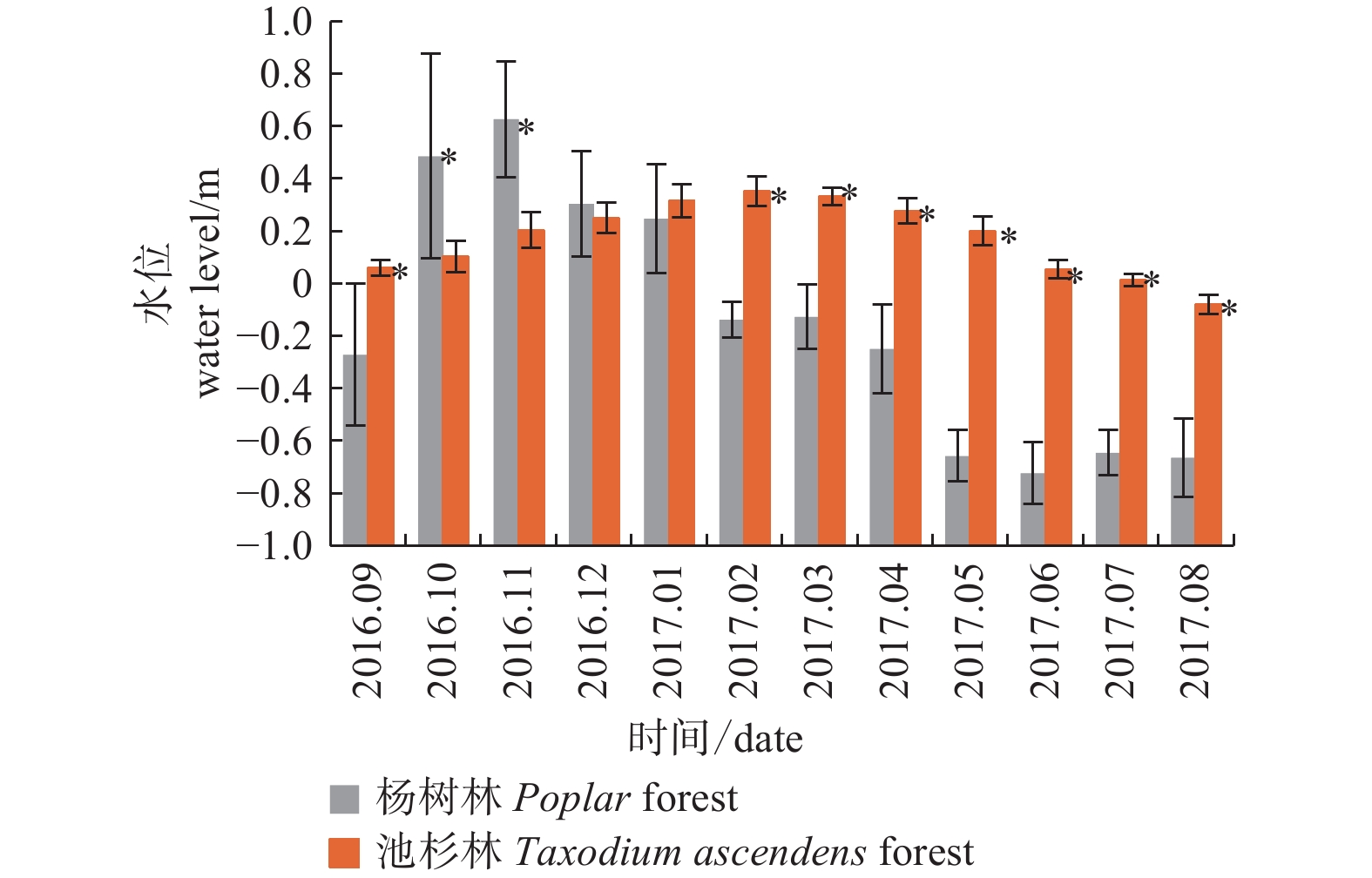
    • 杨树林和池杉林2016年9月至2017年8月地上、地下水水位月际动态变化见图1。从图中可以看出,除了2016年12月和2017年1月,其余10个月两种淡水湿地植被水位月际动态均呈现出极显著的差异性(P < 0.01)。杨树林平均水位为地下0.15 m,月际间变化幅度较大,在地下0.72 m至地上0.62 m范围间变化。池杉林平均水位为0.17 m,月际变化幅度相对较小,水位变化在−0.08 m~0.35 m之间变化,全年几乎处于淹水状态。从地上、地下水位月际动态看,两种典型森林植被地上、地下水位的变化趋势存在极显著的差异(P < 0.01),除了2016年10—12月份杨树林水位高于池杉林外,其余9个月均为池杉林月均水位高于杨树林(图1)。2016年10月—2017年1月,杨树林处于淹水状态,且地上水位最高值出现在2016年11月份,为0.63 m,地下水位最低值出现在6月份,为−0.72 m;池杉林地上、地下水位月际变化趋势较缓,最大值出现在2月份,而最小值出现在8月份。

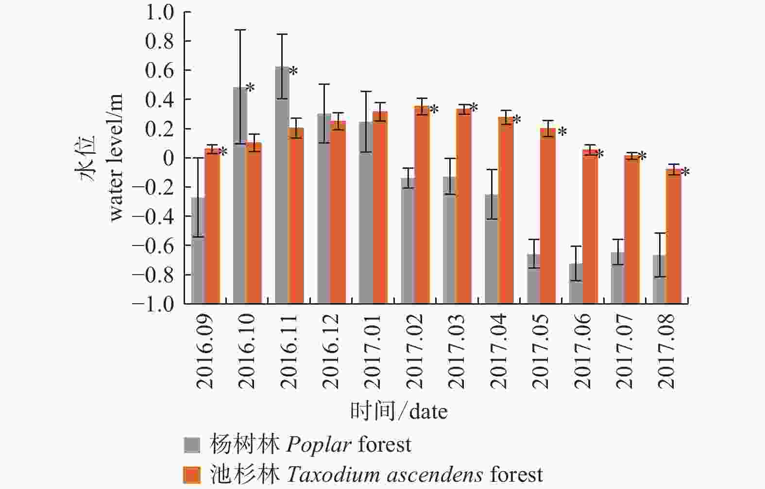
      Figure 1.  Monthly variation of groundwater level under different wetland forests

    • 图2中可看出,在监测期的4个不同季节,两种湿地森林植被差异性显著(P < 0.01)。池杉林常年处于淹水状态,春季、夏季和冬季水位均显著高于杨树林水位。池杉林水位为:冬季 > 春季 > 秋季 > 夏季,冬季和春季地上水位最高值分别为0.30 m和0.27 m,显著高于夏季的水位;而杨树林水位为:秋季 > 冬季 > 春季 > 夏季。杨树林秋季和冬季处于淹水状态,水位显著高于春季和夏季;春季和夏季的水位较低,分别为−0.34 m和−0.68 m。可见,池杉林和杨树林夏季的水位均低于其他季节。

      Figure 2.  Seasonal variation of groundwater level under different wetland forests
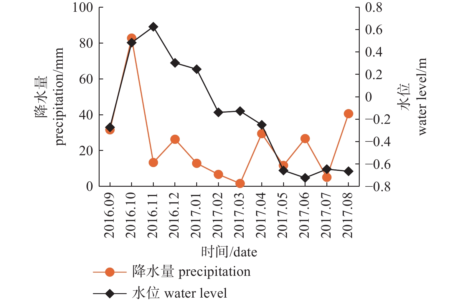
    • 图3图4中可知,杨树林和池杉林秋季和夏季的降水量较大,其中秋季降水量最大,分别占全年降水总量的44.21%和49.58%。冬季和春季降水量偏少,尤其是池杉人工林春季的降水量仅占全年降水总量的7.96%。图3中,受不同季节降水的影响,杨树林经过秋季丰富的降水后,其水位在11月份达到最高值;随后由于冬季和春季降水量减少,水位开始逐渐下降,一直到第二年夏初6月份降到最低。从图3可看出,杨树林水位的变化虽然受降水量影响,但是每个月的降水量对应的地下水水位变化趋势并不是完全一致,而是存在着一定的滞后性。通过pearson相关系数分析发现,杨树林当月的降水量与次月水位之间存在显著的正相关性(R2 = 0.30,P< 0.05),表明一定时间内降水对地下水水位变幅的影响存在一定的滞后性,滞后时间在1个月左右。池杉林降水量的季节变化趋势与杨树人工林一致,但其月平均水位变幅较小,几乎不受降水量的影响。通过相关性分析可得出,池杉林月均地下水水位与其月平均降水量之间均无显著的相关性,且降水对地下水水位的补给的滞后性也未在该淡水湿地森林体现出来。

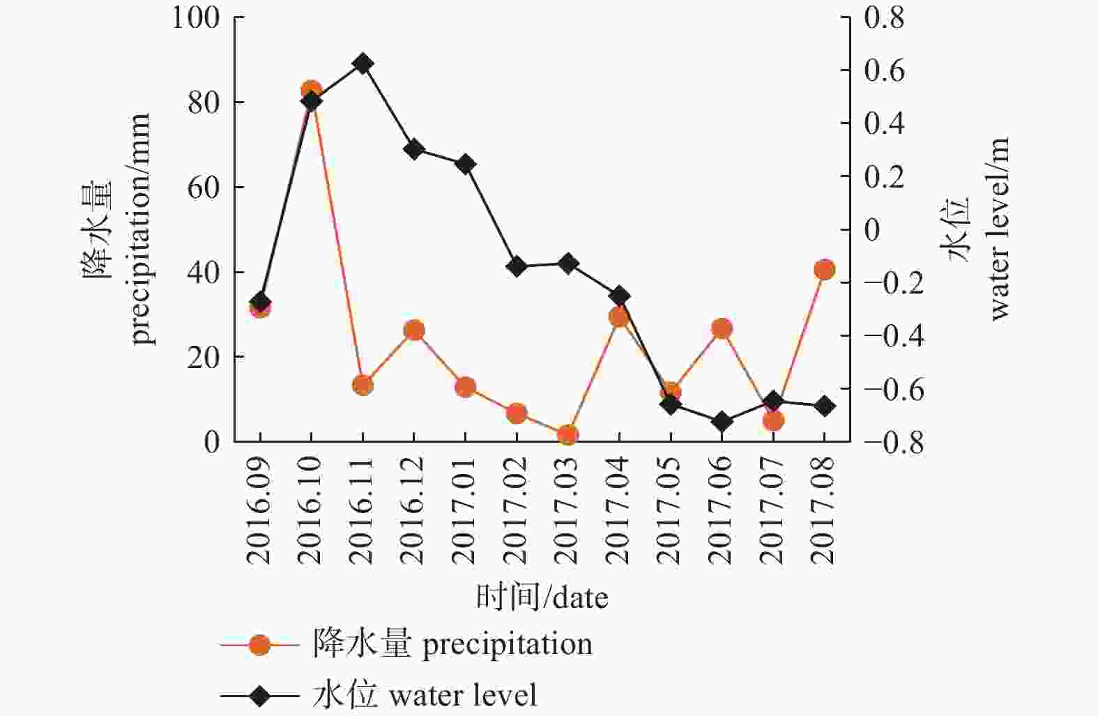
      Figure 3.  The relationship of precipitation and groundwater level under the Poplar forest

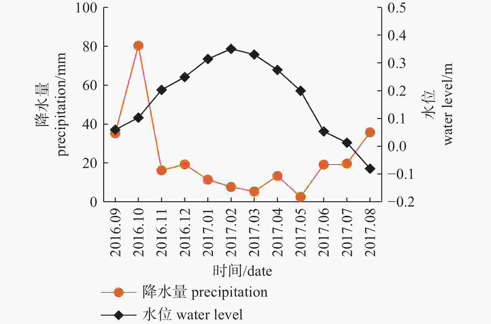
      Figure 4.  The relationship of precipitation and groundwater level under the Taxodium ascendens forest

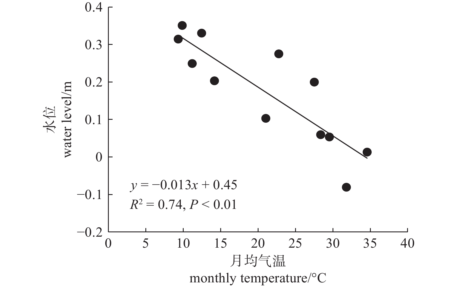
    • 本研究中,从2016年9月至2017年8月,试验区平均气温为21.05 ℃,其中秋季(2016年9—12月)平均气温为21.19 ℃,冬季(2016年12月—2017年2月)平均气温为10.12 ℃,春季(2017年3—5月)平均气温为20.91 ℃,夏季(2017年6—8月)平均气温为31.81 ℃,且呈现出明显的季节性变化规律。通过回归分析发现(图5图6),杨树林和池杉林的月均地下水水位与月均气温之间均呈现出极显著的负相关关系(其中,杨树林R2 = 0.56,P < 0.01; 池杉林R2 = 0.74,P < 0.01)。

      Figure 5.  The relationship of monthly temperature and groundwater level under the Poplar forest

      Figure 6.  The relationship of monthly temperature and groundwater level under the Taxodium ascendens forest

    4.   讨论
    • 从里下河地区池杉林和杨树林这两种淡水湿地森林植被地下水水位的观测结果可得出,两种典型湿地森林地下水水位的月际动态和季节动态都存在极显著的差异。池杉林几乎全年处于淹水状态,杨树林水位季节变化明显,秋季和冬季水位较高,表明不同森林植被对其地下水水位动态的影响程度不同[11]。Csafordi等[12]通过分析匈牙利大草原不同植被覆盖下的20口地下水监测井的地下水水位变化与森林叶面积指数的相关性,也得出了同样的结论。不同森林植被,由于其树木的蒸腾作用以及森林土壤的蒸散强度、蓄水能力等不同,对地下水水位动态的调控作用也有差异[13-14]

      相关研究表明,气象因素会直接或者间接导致地下水水位的变化[15-17]。降水是森林生态系统水循环过程中重要的输入因子,是生态系统中地表水、地下水、土壤水及植物水分等的主要来源,地下水往往由于降水量的补给而水位上升[18-21]。在里下河平原地区,杨树林月均降水量与次月的地下水水位之间存在显著的正相关关系,这与于致龙等[22]的研究中,章古台年内和年际间降水量对地下水水位的上升或者下降的影响均存在时间上的滞后现象一致。幺文和吴淑梅[23]对内蒙古兴安盟地区年内月降水对地下水水位变化的影响进行了分析,同样得出降水对地下水的补给具有滞后性,滞后时间大约为1个月的研究结果,与本研究中杨树林的研究结果相符。池杉林月均地下水水位与降水量无显著的相关性。这是由于池杉林所处的东湖湿地公园水网密布,水流串通,降水量不是影响地下水水位变化的关键因素,对池杉林地下水水位的调控作用小于干旱或半干旱地区[24],即使是降水量较少的冬季和春季,池杉林地下水水位也较高,受降水影响程度较小。因此,在水资源丰富的地区,地下水水位动态与降水量变化不是绝对对应的关系。本研究中杨树林和池杉林月均地下水水位与月均气温表现出极显著的负相关关系,这与Mercau等[24]和Chen等[25]的研究结果一致。主要是由于气温升高,植被蒸腾作用和地面蒸发增加等原因,地下水水位通常会表现出一定程度降低[26-27]。表明在水资源丰富的里下河平原,气温是影响两种典型类型湿地森林地下水水位变化的一个重要气象因子。

    5.   结论
    • 里下河地区,杨树林和池杉林的平均地上、地下水水位分别为地下0.15 m和地上0.17 m。杨树林月际间平均水位变化幅度较大,而池杉林地上、地下水水位大部分月份均大于杨树林,且长期处于淹水状态。杨树林水位随季节变化而逐渐降低,而池杉林地下水水位从秋季到冬季逐渐上升到最高后,在第二年春季和夏季逐渐降低。相对于其他季节,夏季池杉林和杨树林的平均地下水水位均显著较低。杨树林当月的降水量与次月的平均地下水水位之间存在显著的相关性,表明地下水水位动态变化滞后于降水量变化,滞后时间大约为1个月。在水资源丰富的池杉林,其地下水水位受降水量影响较小,二者之间的变化趋势无明显相关性。杨树林和池杉林的月均地下水水位与月均气温间呈现极显著的负相关关系,表明该研究区森林植被地上、地下水水位受气温因素的影响较大。

Reference (27)

Catalog

    /

    DownLoad:  Full-Size Img  PowerPoint
    Return
    Return