


-
深度学习模型是近年来新兴的一类机器学习算法,已被有效的应用于许多领域当中。其中,在遥感领域,该类方法的应用效果也得到了有效的证明。对于遥感地物分类的应用问题,研究表明全卷积类深度神经网络方法(Fully Convolutional Networks,FCN)可有效的解决该问题。方旭等[1]证明通过将均值漂移分割算法与FCN-8s方法相结合能够有效提高高分辨率遥感影像的分类精度,与传统机器学习分类方法SVM相比提高了10%以上的精度。邓国徽等[2]将FCN-8s应用于高分遥感数据的语义分割,以分割图像中的施工场地为例,结果表明:提出的改进全卷积网络模型能够较为显著的提高了施工场地的识别率。Piramanayagam[3]利用FCN将高分辨率遥感影像的光谱信息与DSM的几何信息有效融合,从而提高了高分辨遥感图像的语义分割能力。条件随机场方法(Conditional Random Field,CRF)作为图像处理中常用的能量优化算法,也已被学者证明可有效的改善FCN网络的分类效果[4-5]。
U-net网络是全卷积神经网络模型中常用的一种,该模型通过一个收缩网络以及一个扩张网络,构成了一个U型结构,与经典的FCN网络相比,该网络在上采样过程中可以结合更多层的不同的特征,能够最大程度地保留下采样过程中的一些重要的特征信息[6]。研究表明,该类网络可有效的进行遥感图像信息提取。陈睿敏等[7]使用UNet深度学习模型对红外遥感影像进行5类地物信息提取,其分类效果与传统机器学习方法相比提高了6%。Li等[8]提出了一种卷积块代替卷积层的深度卷积神经网络DeepUNet,提高了海岸线的分割精度。
有研究表明,通过少量的调整相关遥感特征,可以优化FCN深度学习模型的效果[2,9]。邓国徽等[2]提出了融合蓝板房光谱识别指数和裸土光谱识别指数的改进全卷积网络模型,结果表明:添加的指数可以较为显著的提高了施工场地的识别率;Cao Q等[9]将NDVI与CNN的高级特征进行了融合,该算法对土地类型分类效果良好。
本研究借鉴前人对FCN-8s模型的优化思路,基于U-net网络模型,在模型训练过程中通过在原始波段的基础上加入NDVI特征,并增加CRF后处理过程,以期改善U-net深度学习模型用于森林类型分类的效果。
-
旺业甸林场位于赤峰市喀喇沁旗西南部,地理坐标为118°09′~118°30′ E,41°35′~41°50′ N,属于生态主导型多功能林业区。山体相对高度一般为200~400 m,坡度15°~35°。林场林地面积2.57万hm2,其中有林面积是2.33万 hm2。人工林以油松(Pinus tabulaeformis Carr.)、落叶松(Larix principis-rupprechtii May)为主,天然林的树种以白桦(Betula platyphylla Suk),山杨(Populus davidiana Dode)等为主。
-
采用的遥感数据为1景GF-2 PMS多光谱遥感影像(空间分辨率为3.2 m),完全覆盖实验区。成像时间为2015年4月26日,这时地表土壤尚未解冻,植被尚未开始萌芽,油松、落叶松和白桦等森林类型在遥感影像上的区分度较高。
对GF-2多光谱影像进行辐射定标、大气校正、正射校正、影像配准、地形辐射校正等预处理。首先,对GF-2多光谱影像进行辐射定标和FLAASH大气校正,得到地表反射率影像[10]。其次,采用GF-2多光谱影像自带的RPB文件对地表反射率影像进行基于RPC模型的正射校正,所采用的数字高程模型(DEM)为5 m空间分辨率的ZY-3 DEM;然后,以2 m空间分辨率的ZY-3数字正射影像产品(DOM)为参考,采用自动匹配算法对上一步产生的“正射校正”结果影像进行影像到影像的配准处理,并手工采集30个控制点对校正精度进行检验,东西向误差为4.05 m,南北向误差为1.35 m;进一步采用VECA地形辐射校正模型[11]和ZY-3 DEM数据进行了地形辐射校正处理。
-
收集到研究区2007年的矢量小班数据,其数据库包括林种、优势树种、小班面积、地类等属性字段,其中优势树种类型包括油松、落叶松、白桦等,基于该属性字段制作了小班优势树种类型分布图(图1),这里的小班优势树种类型和文本的森林类型具有相同含义,可以作为获取森林类型遥感分类模型训练和精度检验样本的参考数据之一。
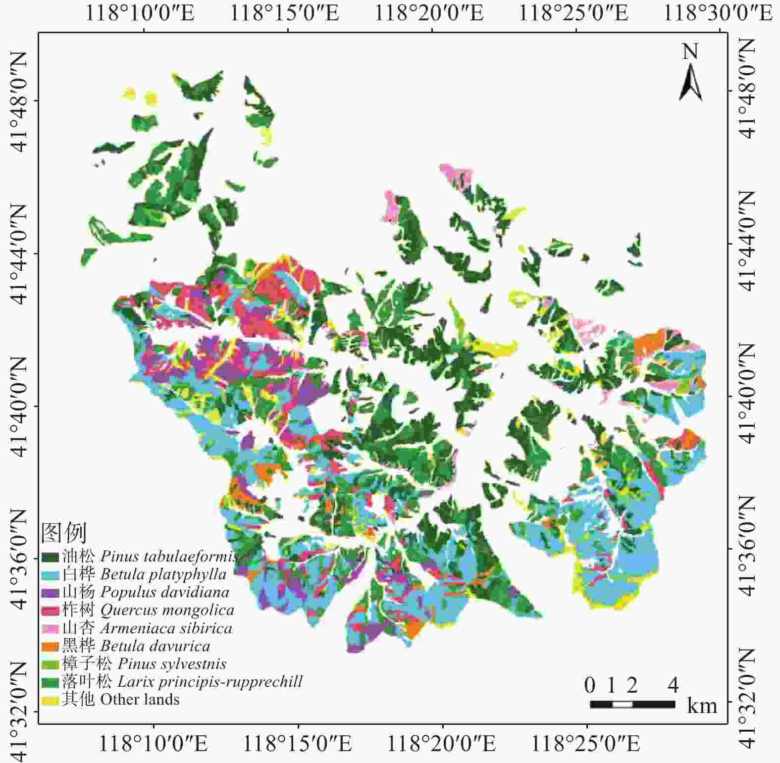
图 1 旺业甸林场优势树种类型分布图
Figure 1. Distribution map of dominant tree species in Wangyedian Forest Farm
-
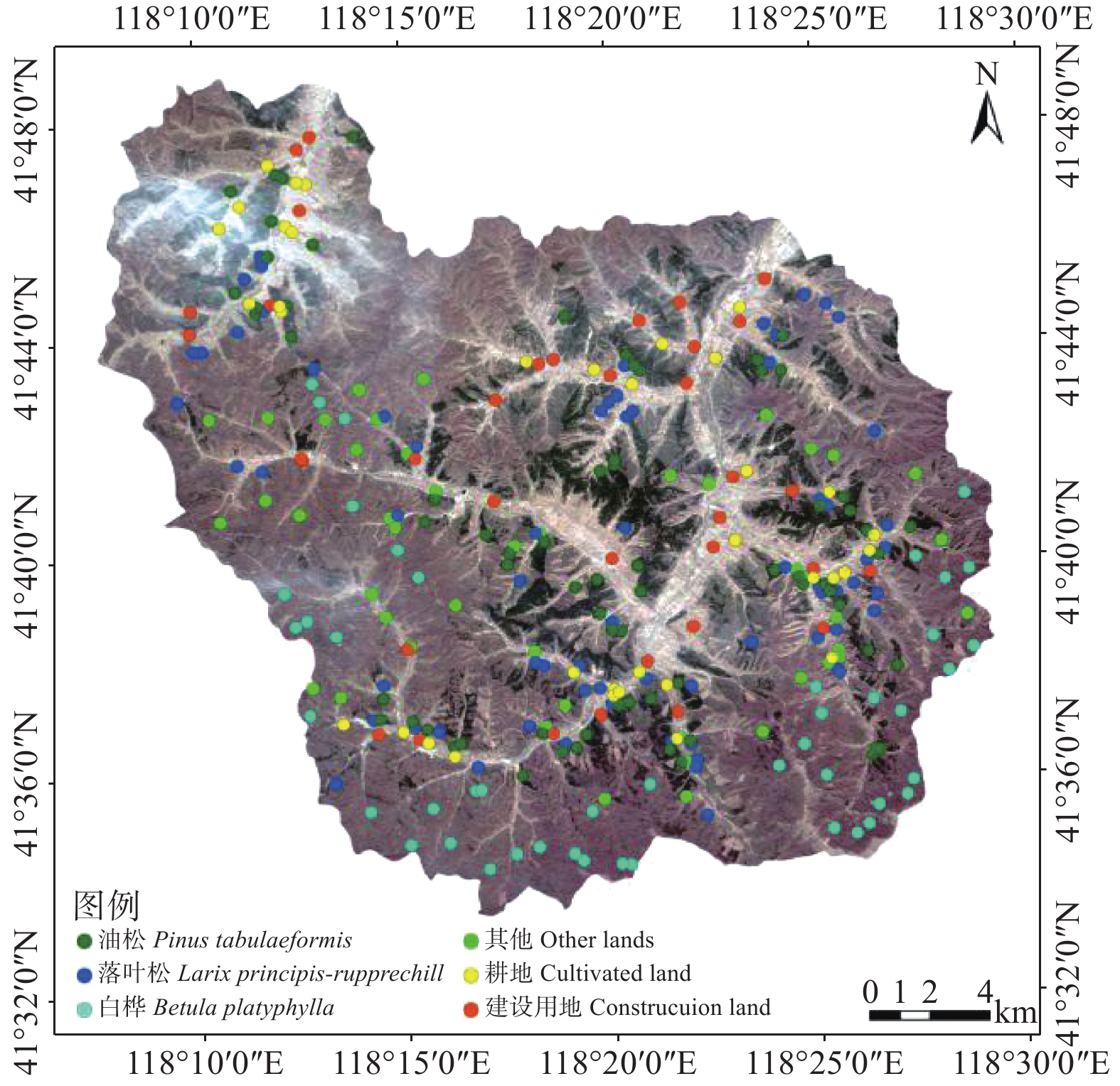
外业调查于2017年9月开展,通过实地调查,共采样旺业甸林场内311个样点,包含的主要森林类型有落叶松、油松、白桦、杨树、榆树等,其中分布最为广泛的为落叶松和油松。图2给出了所调查样点的空间分布,样点基本覆盖整个林场,其中油松样点74个,落叶松69个,白桦46个,其他林地46个,耕地36个以及建设用地40个。外业调查过程中,对所调查样点在2015年的实际地类进行了分析判断,确保不会因调查时间和遥感影像成像时间不一致导致地物类型判断出现偏差。
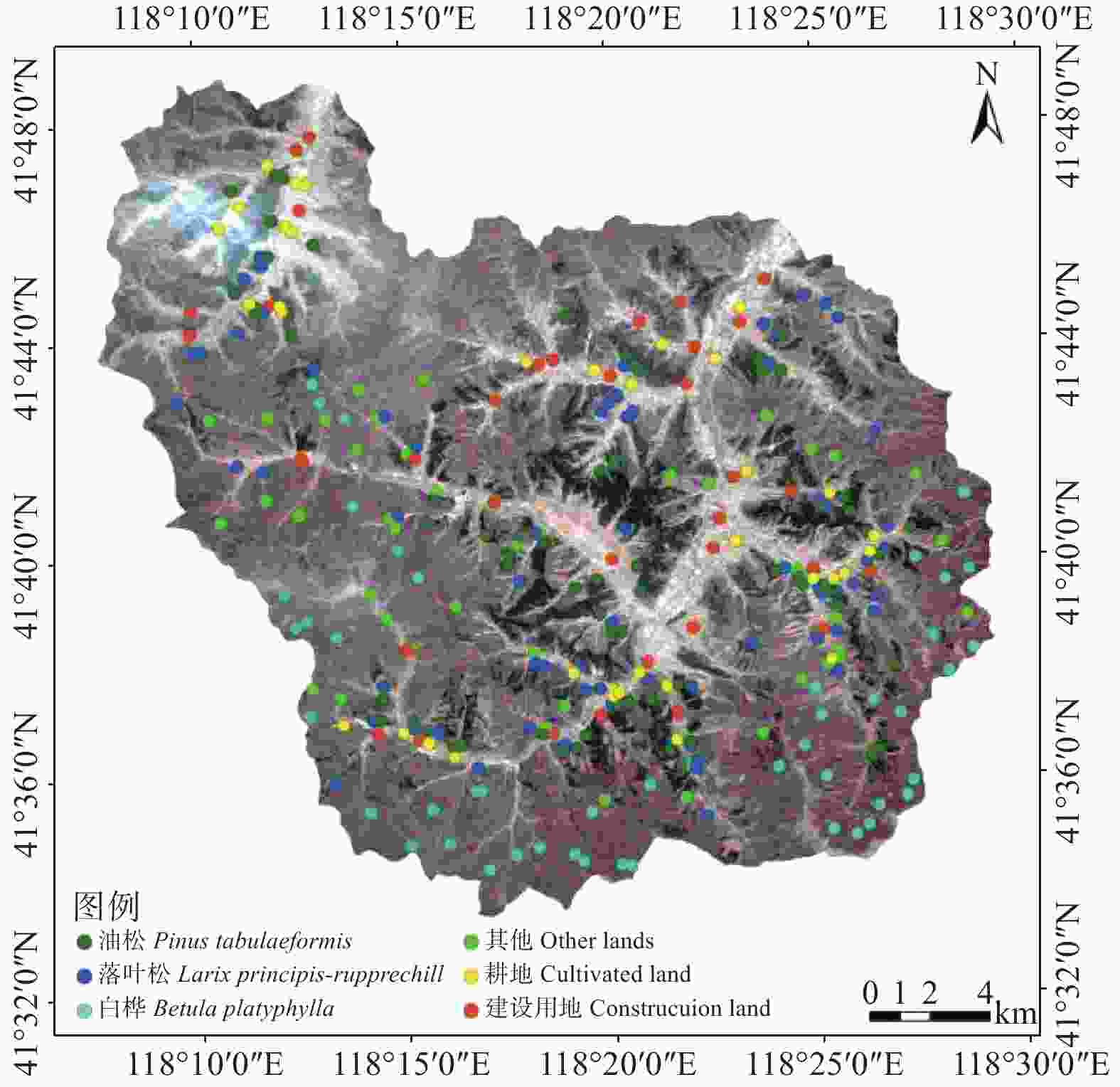
图 2 主要地类的外业调查样点分布图
Figure 2. Distribution map of field sample points of the major land types
-
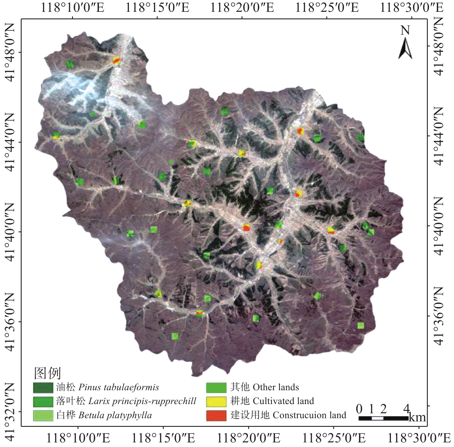
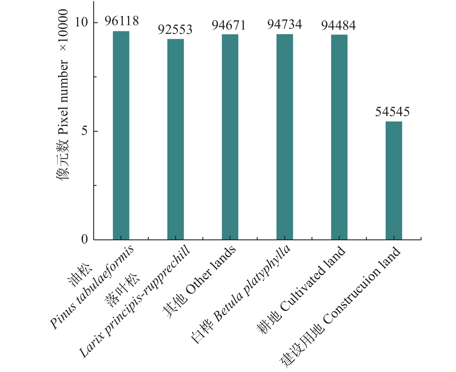
深度学习网络模型的训练需要输入块(Patch)状的样本,本研究参考小班优势树种分布图(图1)、外业调查数据,通过目视解译制作样本块。共制作了样本块142块,其中114块作为训练样本,28块作为验证样本。从图3可以看出,训练样本块在空间上的分布较均匀,而且作者还特地调整了各地类样本像元的数量,尽量使各类别的样本像元数相差不大,但由于研究区建设用地太少,其样本数量和其他类别差别仍然较大。图4为各地类样本像元数对比图。所选取的每个样本块的大小并不一致,为了训练深度学习网络模型的需要,采用最临近值法将不同大小的样本块统一重采样为256像元×256像元大小。
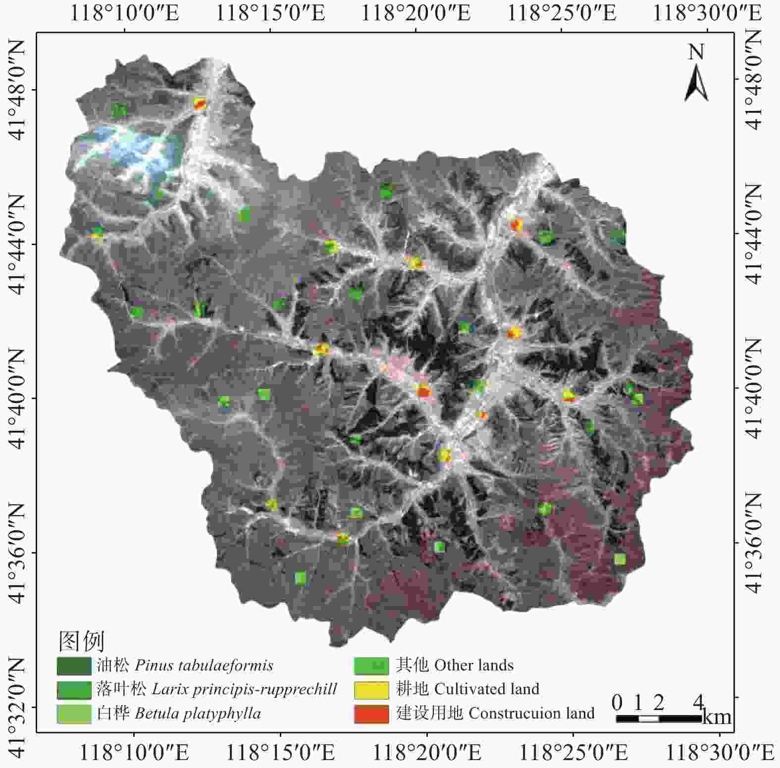
图 3 样本块的空间分布图
Figure 3. Spatial distribution of the sample patchs
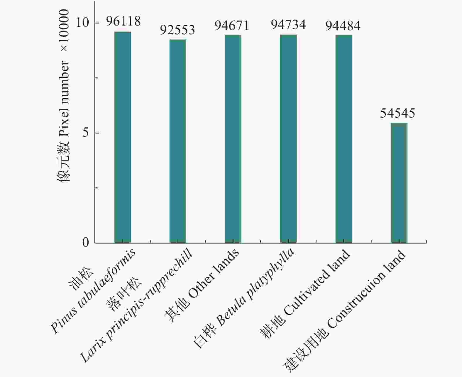
图 4 各地类像元数量
Figure 4. Total pixel number of each land types
为了能够采用统一的标准比较评价传统机器学习模型和深度学习模型,SVM、RF模型的训练和精度检验也采用上述的同一套样本块。
-
依据研究区出现的地类及其空间分布特点,在外业调查数据和已有小班数据的支持下,通过对GF-2遥感影像进行预分类,对能够有效区分的潜在地类进行了分析,最终确定了本研究的待分类类别包括:落叶松、油松、白桦、耕地、建设用地和其他。其中前3个地类属于有林地的细分类别,是以林地上林分的优势树种类型名称作为类别名称。其他地类主要包括在该研究区面积占比很小的樟子松、云杉、榆树等。
-
本文研究从3个部分展开分类方法研究:首先,提取NDVI特征,其次,基于NDVI特征和原始影像4个波段,共计5个特征的数据构建深度U-net模型并进行分类;最后,对分类结果进行CRF后处理。在本研究中,将上述流程简称为U-net-NDVI-CRF方法。
-
U-net网络由一个收缩网络以及一个扩张网络构成,一共包含23个卷积层。其网络的结构具体为:收缩网络主要用于重采样的过程,随着网络深度的增加,提取高维抽象特征,每一次重采样都包含两个3×3的卷积操作,使用修正线性单元(rectified linear unit,ReLU)作为激活函数。每一次重采样的卷积操作将图片的尺寸变为原来图片尺寸大小的1/2,特征通道变为原来的两倍;扩张网络主要对收缩网络中的特征进行过采样的工作,每一次过采样包含两个3×3的卷积操作,同样使用RuLU作为激活函数。在每一次上采样后,图片大小变为原来的2倍,特征数量变为原来的1/2[6]。在上采样操作中,将每一次输出的特征与对应的收缩网络特征合并在一起,补全中间丢失的特征信息。最后,加入1×1的卷积操作将之前所获得的特征映射到所属类别上[6]。
-
U-net模型基于Tensorflow框架训练,使用Adam方法作为优化器来训练网络,学习率为0.001。网络的权重共更新10 000次。网络在一块NVIDIA Quadro K5200显卡上训练,GPU内存为8G。
本研究使用SVM和RF分类器作对比实验[12-13]。针对SVM模型,设置核函数为GRBF(Gaussian radial basis function),使用的目标函数类型是C-支持向量分类(C-SVC),最优惩罚因子C和核函数参数γ进行自动寻优。针对RF模型,实验中设置的决策树的数量为100,每个决策树随机选择的5个特征构建模型,并通过投票法得到分类类别。
-
以外业调查样本地类为各地类真值,对分类的正确性进行检验,采用的评价指标包括分类混淆矩阵,得到制图精度、用户精度、总体分类精度及Kappa系数。
-
基于U-net-NDVI-CRF方法的分类结果混淆矩阵如表1所示,总体分类精度达84.89%,Kappa系数为0.82。除落叶松和其他地类外,各地类制图精度均在83%以上。其中,其他地类精度较低,易错分为白桦,主要原因在于GF-2多光谱数据成像时间为冬季,其他地类(主要包括榆树、杨树、柞树等植被类型)均属于落叶性植被,他们的光谱曲线和NDVI特征与白桦差异较小,容易导致误分。落叶松存在部分错分为油松的情况,主要原因在于此季节的落叶松已经开始萌芽,且与油松同属于针叶林、人工林,在光谱和纹理上具有一定的相似性,造成部分落叶松错分为油松。
表 1 U-net-NDVI-CRF方法的分类结果混淆矩阵
Table 1. Confusion matrix of U-net-NDVI-CRF classification result
类别名称
Informational classes油松
Pinus
tabulaeformis落叶松
Larix principis-
rupprechtii其他
Other lands白桦
Betula platyphylla耕地
Cultivated land建设用地
Construcuion land总计
Total油松 Pinus tabulaeformis 74 15 1 0 0 0 90 落叶松 Larix principis-rupprechtii 0 51 2 1 0 0 54 其他 Other lands 0 1 29 4 3 0 37 白桦 Betula platyphylla 0 2 13 41 0 0 56 耕地 Cultivated land 0 0 0 0 30 1 31 建设用地 Construcuion land 0 0 1 0 3 39 43 总计 Total 74 69 46 46 36 40 311 制图精度 Producer accuracy/% 100 73.91 63.04 89.13 83.33 97.5 用户精度 User accuracy/% 82.22 94.44 78.38 73.21 96.77 90.7 注:总体精度:84.89%;Kappa系数:0.82。Note:Overall accuracy: 84.89%; Kappa coefficient: 0.82. -
加入NDVI特征前后U-net模型分类精度对比如表2所示。从表中可以看出,加入NDVI特征之后,分类精度得到有效的提高,总体精度提高了2.25%,Kappa系数提高了0.02,其他地类、耕地、建设用地的分类精度有显著提高,其中,其他地类提高了15.22%,耕地提高了13.89%。从分类细节图(图5)中可以看出,加入NDVI特征可有效改善林地分布区域的分类效果。
-
加入CRF前后U-net分类结果的精度对比如表2所示。在加入CRF后,总体精度较之前提高了0.65%,Kappa系数提高了0.01,其中,落叶松和其他地类的精度有所提高。从定量上的分析可见,分类精度提升幅度并不大,但从目视角度分析,各类地物之间的边缘得到细化。从分类细节图(图5)可以看出,在其他和白桦混交的区域,采用CRF后处理分类效果提升的贡献明显。
表 2 加入NDVI特征以及CRF前后U-net分类结果的精度对比
Table 2. Accuracy comparison of U-net classification results before and after adding NDVI features and CRF
项目
Items油松
Pinus tabulaeformis落叶松
Larix principis-rupprechtii其他
Other lands白桦
Betula platyphylla耕地
Cultivated land建设用地
Construcuion land总体精度
Overall accuracyKappa系数
KappaRGB-IR 100% 72.46% 45.65% 100% 69.44% 97.5% 81.99% 0.79 RGB-IR-NDVI 100% 71.01% 60.87% 89.13% 83.33% 100% 84.24% 0.81 RGB-IR-NDVI CRF 100% 73.91% 63.04% 89.13% 83.33% 97.5% 84.89% 0.82 注:所有精度均为制图精度。Note:All accuracy is producer accuracy. 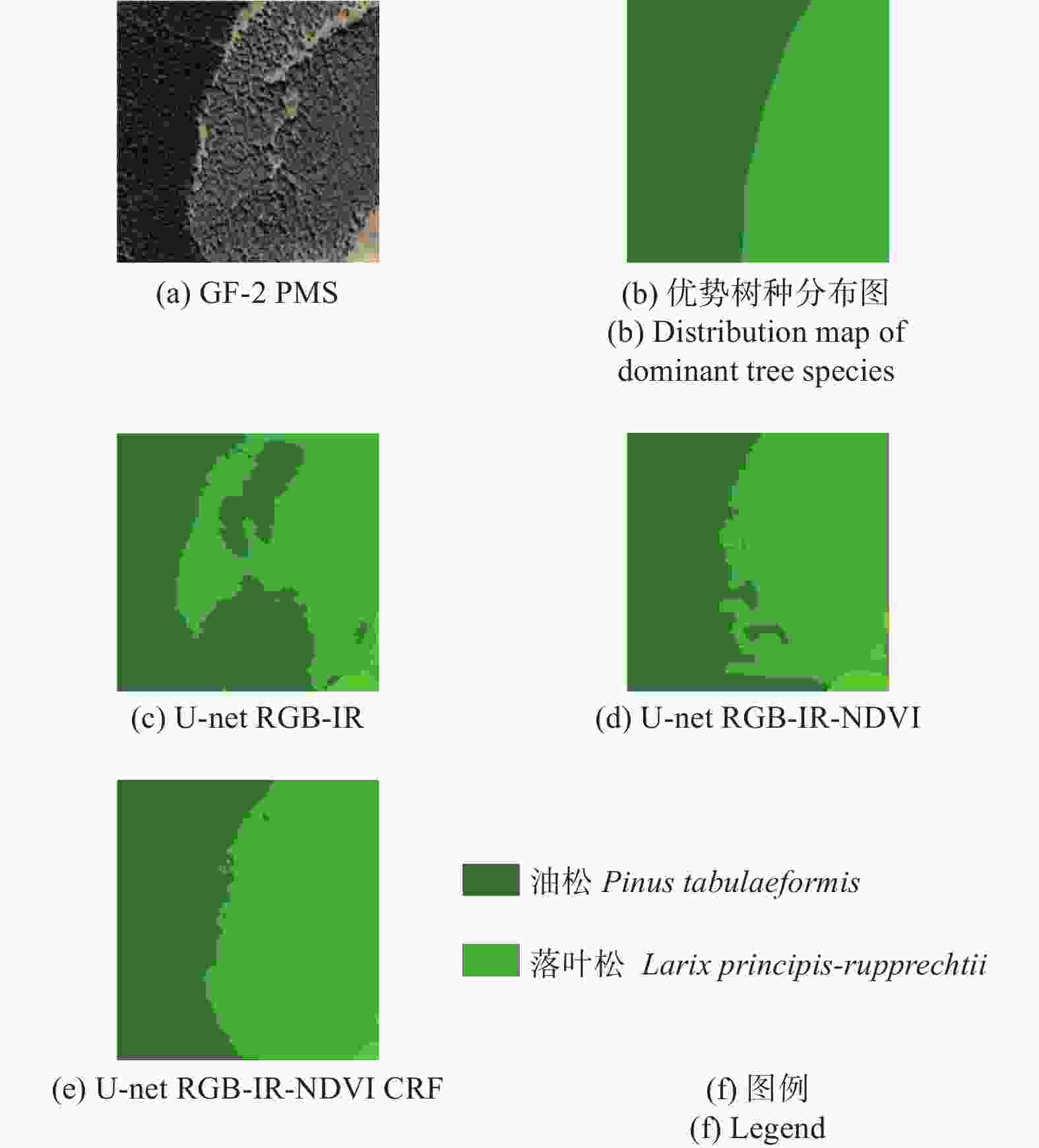
图 5 部分油松、落叶松分类结果细节图
Figure 5. The detailed classification results
-
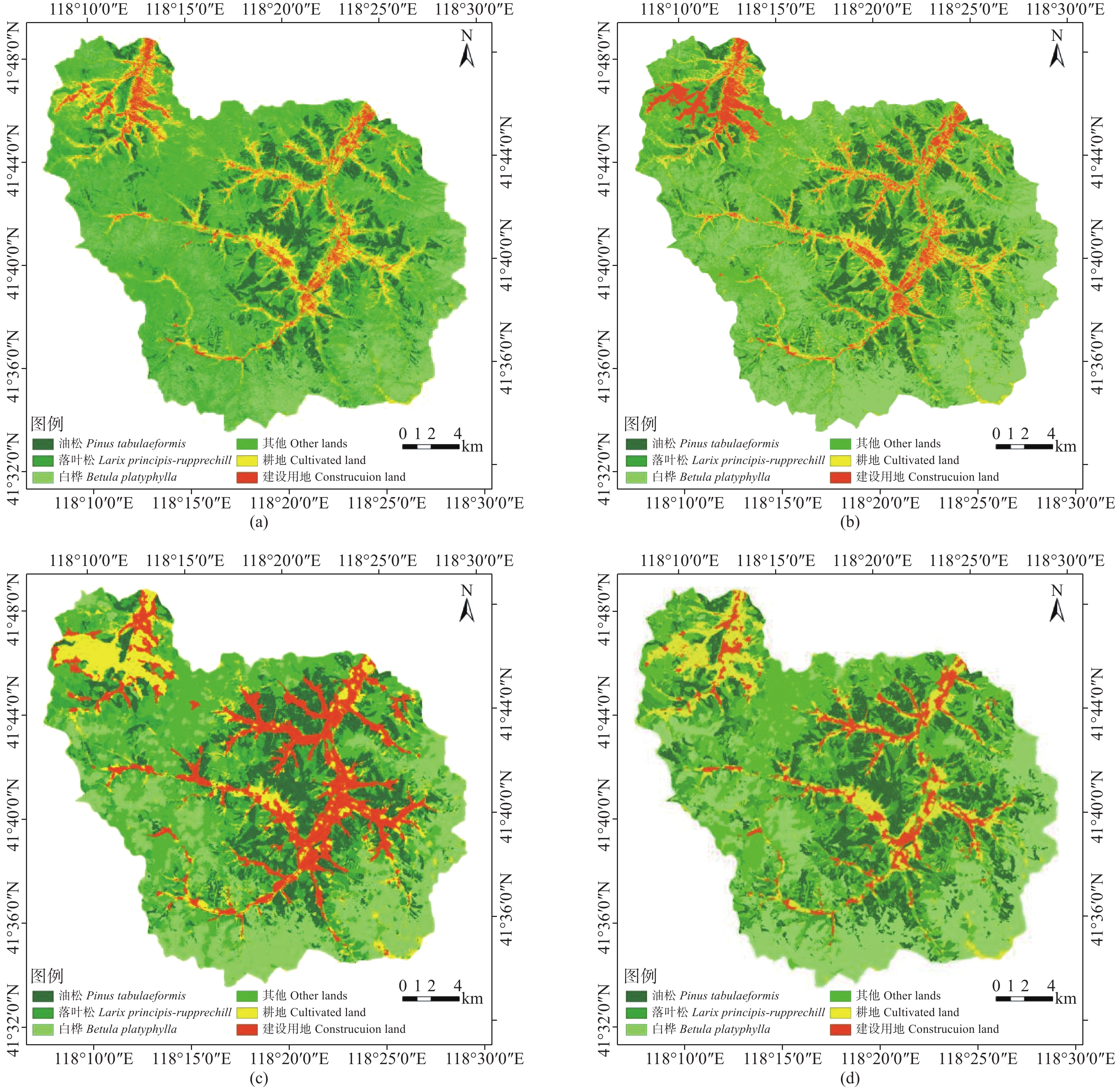
为了验证本研究所设计的U-net-NDVI-CRF分类方法的有效性,将其与加入NDVI特征的传统机器学习SVM、RF的分类结果,加入NDVI特征和CRF的FCN-8s的分类结果进行了比较分析。这4种分类方法的分类结果如图6所示,分类精度对比如表3所示。深度学习U-net、FCN-8s模型的总体精度和Kappa系数均高于SVM、RF。U-net的总体精度和Kappa系数明显高于其他模型,对油松、白桦、耕地、建设用地和其他的分类精度均较高,尤其是其他地类的分类表现更为突出。对于落叶松,U-net的分类精度较低,主要原因为落叶松与油松同属于人工林,在空间特征上存在一定的相似性,使得油松和落叶松存在一定的混淆。对建设用地,U-net和FCN-8s比SVM或RF改进很多,主要是因为此季节的建设用地和耕地在光谱上存在一定的相似性,且耕地中的大棚与建设用地十分相似,U-net和FCN-8s可以自动提取特征以区分两个地类,而SVM和RF仅靠光谱特征不能完全将建设用地与耕地等地类分出。从分类细节图(图7)可以看出,U-net-NDVI-CRF对油松和落叶松的分类效果要好明显于其他分类方法。
表 3 4种相关分类方法的分类精度对比
Table 3. Comparisons of classification accuracy of four relevant methods
模型
Model油松
Pinus tabulaeformis落叶松
Larix principis-
rupprechtii其他
Other lands白桦
Betula platyphylla耕地
Cultivated land建设用地
Construcuion land总体精度
Overall accuracyKappa系数
KappaRF 95.95% 75.36% 47.83% 67.39% 66.67% 62.5% 72.35% 0.66 SVM 97.30% 91.30% 36.96% 89.13% 58.33% 62.5% 76.85% 0.72 FCN-8s 100% 81.16% 34.78% 86.96% 52.78% 97.5% 78.46% 0.74 U-net 100% 73.91% 63.04% 89.13% 83.33% 97.5% 84.89% 0.82 注:所有精度均为制图精度。Note:All accuracy is producer accuracy. 
图 6 分类结果 (a) RF;(b) SVM;(c) FCN-8s;(d) U-net
Figure 6. Classification result (a) RF; (b) SVM; (c) FCN-8s; (d) U-net
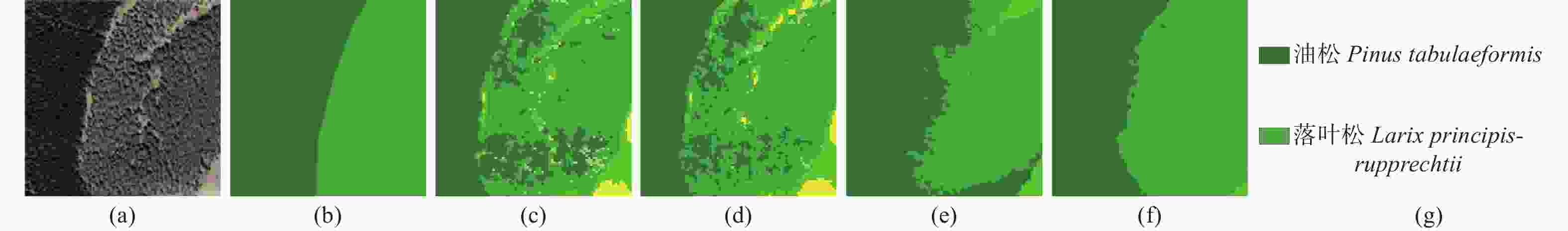
图 7 局部区域油松、落叶松4种分类方法的分类结果对比:(a) GF-2 PMS;(b) 优势树种分布图;(c) RF;(d) SVM;(e) FCN-8s;(f) U-net;(g) 图例
Figure 7. Comparison of classification result of the four classification method for some region: (a) GF-2 PMS; (b) Distribution map of dominant tree species; (c) RF; (d) SVM; (e) FCN-8s; (f) U-net; (g)Legend
-
(1)本研究采用U-net网络模型结合CRF对5个特征(原始四波段以及NDVI)的GF-2 PMS 3.2 m的遥感数据进行森林类型分类,总体分类精度为84.89%,与传统的机器学习分类方法RF、SVM在同等五波段时的分类结果相比,提高了8.04%至12.54%,提升效果显著,该结论与已有的将深度学习网络模型用于土地覆盖/利用遥感分类的文献所得到的结论一致[2, 5, 9]。
(2)虽然深度学习方法,可以自动提取遥感特征,但是现有文献[2]、[9]表明,可以通过加入NDVI等少量特征可以提高分类精度。本研究为与机器学习分类方法在数据上形成对等性,不进行过多的手动提取和选择特征的步骤,选取NDVI与影像原始4个波段组成5个特征的数据进行分类,机器学习SVM、RF分类精度低于U-net的分类精度。
(3)由于采用的遥感影像成像时间和光谱限制,其他地类(主要包括榆树、杨树、柞树等植被类型)均属于落叶性植被,他们的光谱曲线和NDVI特征与白桦差异较小,造成目视解译困难,对分类结果造成了一定的影响。因此,考虑使用生长季影像对其他地类进行细化之后进行深度学习精细分类。
(4)本研究实验采用的数据是GF-2 PMS 3.2 m分辨率的遥感数据,而全色数据的分辨率可达0.8 m,结合纹理信息丰富的全色数据进行实验,对比在更高分辨率下地物的边缘信息是否更好的保留为下一步的研究方向。且本研究的GF-2 PMS遥感数据的时相为4月,使得其他地类的光谱差异不明显,使用生长季的数据进行森林类型的精细分类是下一步的研究方向。
-
针对国家森林资源规划设计调查业务对高分辨率多光谱遥感分类技术的应用需求,发展了一种深度学习森林类型遥感分类方法。研究结果表明,通过加入NDVI特征可有效提高U-net网络森林类型分类结果的精度,采用CRF后处理则可以有效改善分类效果,且与FCN-8s、SVM、RF相比,优化后的U-net分类效果有较大的提升。
与传统机器学习分类方法相比,本研究所发展的方法可以自动提取遥感特征,从而可有效避免传统方法由于手工提取和选择特征等而导致的分类结果容易受人为因素影响的问题,具有更高的可操作性。当然,目前深度学习方法还存在对高性能GPU计算机依赖性强,模型训练耗时,技术门槛较高等问题。随着我国高性能GPU计算机的快速普及和计算能力的快速提高,这些制约深度学习分类方法林业业务化应用的障碍将很快得到克服,在本研究研究的基础上,针对林业遥感业务特点,通过深度学习网络结构的创新设计,进一步提高分类精度和效率,具有重要的研究和应用价值。
高分辨率多光谱遥感影像森林类型分类深度U-net优化方法
Deep U-net Optimization Method for Forest Type Classification with High Resolution Multispectral Remote Sensing Images
-
摘要:
目的 使用深度学习全卷积神经网络U-net的自动特征提取,有效地改善遥感目标识别及地物分类的效果。 方法 以内蒙古自治区赤峰市旺业甸林场为研究区,主要数据源包括GF-2多光谱数据、ZY-3 DOM数据、ZY-3 DEM数据、小班数据以及外业实地调查数据等。借鉴前人对FCN-8s模型的优化思路,基于U-net网络模型,在模型训练过程中通过在原始波段的基础上加入标准归一化植被指数(NDVI)构建网络,并增加条件随机场后处理过程,得到最终的分类结果。 结果 表明:(1)优化后的U-net模型的总体分类精度达84.89%,Kappa系数为0.82,分别高于未加入标准归一化植被指数特征的U-net模型以及未使用条件随机场进行后处理的U-net模型的分类精度;(2)优化后的U-net模型与使用相同策略的FCN-8s,支持向量机和随机森林的分类结果相比,提高了8.04%~12.54%,分类精度大幅度提高。 结论 通过少量调整相关的遥感特征以及使用条件随机场后处理方法可改善U-net模型的分类效果,适用于基于U-net的森林类型高分辨率多光谱遥感影像分类。 Abstract:Objective Full convolution neural network U-net can effectively improve the effect of remote sensing target recognition and object classification. Method The test site is located in Wangyedian Forest Farm, Chifeng district, Inner Mongolia Autonomous Region. The GF-2 multispectral data, ZY-3 DOM data, ZY-3 DEM data, subcompartment data and field survey data were employed as the key data sources. Based on the U-net network model and the optimization ideas of the previous FCN-8s model, the standard Normalize Different Vegetation Index (NDVI) was added to the original band in the training process, and the CRF post-processing process was added to construct the network and the final classification results were obtained. Result (1) The overall classification accuracy of the optimized U-net model was 84.89%, and the Kappa coefficient was 0.82, which was higher than that of the U-net model without NDVI feature and U-net model without CRF post-processing; (2) Compared with the classification results of FCN-8s, SVM and RF using the same strategy, the classification accuracy of the optimized U-net model was greatly improved. Conclusion The classification effect of U-net model can be improved by adjusting the relevant remote sensing features and using CRF post-processing method. This method is suitable for the classification of high resolution multispectral remote sensing images of forest types. -
Key words:
- U-net
- / GF-2 multispectral data
- / NDVI
- / CRF
- / forest type classification
-
图 1 旺业甸林场优势树种类型分布图
Figure 1. Distribution map of dominant tree species in Wangyedian Forest Farm
图 2 主要地类的外业调查样点分布图
Figure 2. Distribution map of field sample points of the major land types
图 6 分类结果 (a) RF;(b) SVM;(c) FCN-8s;(d) U-net
Figure 6. Classification result (a) RF; (b) SVM; (c) FCN-8s; (d) U-net
图 7 局部区域油松、落叶松4种分类方法的分类结果对比:(a) GF-2 PMS;(b) 优势树种分布图;(c) RF;(d) SVM;(e) FCN-8s;(f) U-net;(g) 图例
Figure 7. Comparison of classification result of the four classification method for some region: (a) GF-2 PMS; (b) Distribution map of dominant tree species; (c) RF; (d) SVM; (e) FCN-8s; (f) U-net; (g)Legend
表 1 U-net-NDVI-CRF方法的分类结果混淆矩阵
Table 1. Confusion matrix of U-net-NDVI-CRF classification result
类别名称
Informational classes油松
Pinus
tabulaeformis落叶松
Larix principis-
rupprechtii其他
Other lands白桦
Betula platyphylla耕地
Cultivated land建设用地
Construcuion land总计
Total油松 Pinus tabulaeformis 74 15 1 0 0 0 90 落叶松 Larix principis-rupprechtii 0 51 2 1 0 0 54 其他 Other lands 0 1 29 4 3 0 37 白桦 Betula platyphylla 0 2 13 41 0 0 56 耕地 Cultivated land 0 0 0 0 30 1 31 建设用地 Construcuion land 0 0 1 0 3 39 43 总计 Total 74 69 46 46 36 40 311 制图精度 Producer accuracy/% 100 73.91 63.04 89.13 83.33 97.5 用户精度 User accuracy/% 82.22 94.44 78.38 73.21 96.77 90.7 注:总体精度:84.89%;Kappa系数:0.82。Note:Overall accuracy: 84.89%; Kappa coefficient: 0.82.  下载: 导出CSV
表 2 加入NDVI特征以及CRF前后U-net分类结果的精度对比
Table 2. Accuracy comparison of U-net classification results before and after adding NDVI features and CRF
项目
Items油松
Pinus tabulaeformis落叶松
Larix principis-rupprechtii其他
Other lands白桦
Betula platyphylla耕地
Cultivated land建设用地
Construcuion land总体精度
Overall accuracyKappa系数
KappaRGB-IR 100% 72.46% 45.65% 100% 69.44% 97.5% 81.99% 0.79 RGB-IR-NDVI 100% 71.01% 60.87% 89.13% 83.33% 100% 84.24% 0.81 RGB-IR-NDVI CRF 100% 73.91% 63.04% 89.13% 83.33% 97.5% 84.89% 0.82 注:所有精度均为制图精度。Note:All accuracy is producer accuracy.
下载: 导出CSV
表 3 4种相关分类方法的分类精度对比
Table 3. Comparisons of classification accuracy of four relevant methods
模型
Model油松
Pinus tabulaeformis落叶松
Larix principis-
rupprechtii其他
Other lands白桦
Betula platyphylla耕地
Cultivated land建设用地
Construcuion land总体精度
Overall accuracyKappa系数
KappaRF 95.95% 75.36% 47.83% 67.39% 66.67% 62.5% 72.35% 0.66 SVM 97.30% 91.30% 36.96% 89.13% 58.33% 62.5% 76.85% 0.72 FCN-8s 100% 81.16% 34.78% 86.96% 52.78% 97.5% 78.46% 0.74 U-net 100% 73.91% 63.04% 89.13% 83.33% 97.5% 84.89% 0.82 注:所有精度均为制图精度。Note:All accuracy is producer accuracy.
下载: 导出CSV
-
[1] 方 旭, 王光辉, 杨化超, 等. 结合均值漂移分割与全卷积神经网络的高分辨遥感影像分类[J]. 激光与光电子学进展, 2018, 55(2):1-9. [2] 邓国徽, 高 飞, 罗志鹏. 基于改进的全卷积神经网络高分遥感数据语义分割研究[C]//第四届高分辨率对地观测学术年会论文集, 2017: 1-13. [3] Piramanayagam S. Classification of remote sensed images using random forests and deep learning framework[J]. Proceedings of the Spie, 2016, 4: 1-8 [4] Chen L C, Papandreou G, Kokkinos I, et al. DeepLab: Semantic Image Segmentation with Deep Convolutional Nets, Atrous Convolution, and Fully Connected CRFs[J]. IEEE Transactions on Pattern Analysis & Machine Intelligence, 2016, 40(4): 834-848. [5] 夏 梦, 曹 国, 汪光亚, 等. 结合深度学习与条件随机场的遥感图像分类[J]. 中国图象图形学报, 2017, 22(9):1-13. [6] Ronneberger O, Fischer P, Brox T. U-Net: Convolutional Networks for Biomedical Image Segmentation[M]. Medical Image Computing and Computer-Assisted Intervention, 2015: 234-241. [7] 陈睿敏, 孙胜利. 基于深度学习的红外遥感信息自动提取[J]. 红外, 2017, 38(8):1-7. doi: 10.3969/j.issn.1672-8785.2017.08.001 [8] Li R, Liu W, Yang L, et al. DeepUNet: A Deep Fully Convolutional Network for Pixel-level Sea-Land Segmentation[J]. IEEE Journal of Selected Topics in Applied Earth Observations & Remote Sensing, 2018: 1-9. [9] Cao Q, Zhong Y, Ma A, et al. Urban Land Use/Land Cover Classification Based on Feature Fusion Fusing Hyperspectral Image and Lidar Data[C]//IGARSS 2018-2018 IEEE International Geoscience and Remote Sensing Symposium. IEEE, 2018: 8869-8872. [10] 郝建亭, 杨武年, 李玉霞, 等. 基于FLAASH的多光谱影像大气校正应用研究[J]. 遥感信息, 2008(1):78-81. doi: 10.3969/j.issn.1000-3177.2008.01.015 [11] 高永年, 张万昌. 遥感影像地形校正研究进展及其比较实验[J]. 地理研究, 2008, 27(2):467-477. doi: 10.3321/j.issn:1000-0585.2008.02.024 [12] 刘怡君, 庞 勇, 廖声熙, 等. 机载LiDAR和高光谱融合实现普洱山区树种分类[J]. 林业科学研究, 2016, 29(3):407-412. doi: 10.3969/j.issn.1001-1498.2016.03.015 [13] 任 冲, 鞠洪波, 张怀清, 等. 天水市近30年林地动态变化遥感监测研究[J]. 林业科学研究, 2017, 30(1):25-33. -

 点击查看大图

计量
- 文章访问数: 7352
- HTML全文浏览量: 4072
- PDF下载量: 190
- 被引次数: 0
