

-
土壤大孔隙是能优先传导土壤水和溶质的半径较大的孔隙[1],其空间有较高的自相似性和异质性,孔隙大量富集形成联通的孔隙通道,使土壤水和溶质避开基质土壤,快速运移到深层土壤补给地下水,产生大孔隙流[2-3]。大孔隙有重要的生态水文意义,其数量占孔隙度比例虽小,却传导90%土壤水分和溶质,同时在水循环和蓄水持水中起重要作用[4]。研究显示,用分形值表示土壤孔隙大小、颗粒含量占土壤空间的有效性[5],因而引入分形理论以描述土壤非均匀结构特征[6]。
连通性强的孔隙可调控壤中流过程,是森林涵养水源和调节水文功能的重要方式[7],Soto-Gómez D[8]研究表明,土地有机管理模式下土壤大孔隙连通性较好,而李荣磊等[9]研究发现,土壤中由细小孔隙构成的复杂孔径会阻止Cl-的运移,Yu F[10]、Meng C[11]等使用CT扫描技术结合原位染色方法,获取土柱孔隙三维结构,定量描述土壤孔隙数量和形态特征表明,不同绿洲农地和不同森林群落土壤孔隙特性有显著差异,相较于单一林分,群落结构越复杂,土壤结构对水、溶质和空气的运输越高效。对大孔隙的研究还集中于其入渗性能,王金悦[12]等通过土壤水分特征研究孔隙特征和入渗性能,Zhang Y[13]等森林群落内植物根系对优先路径的影响。土壤分形特征反映了孔隙状况[14]和结构的稳定性[15-16],Fei Qi[17]等研究表明相比土壤颗粒细化,土壤质量提高,促进土壤形成良好的结构。对土壤颗粒和团聚体分形研究可知,土壤中的细颗粒结构对维持土壤良好结构和有机无机胶结过程起主要作用[18],土壤分形特征与土壤颗粒大小和含量密切相关。
土壤理化特性和有效养分是群落演替的前提[19],土壤水分[20]和微生物群落[21-22]是群落演替的重要因素,由水热条件和微生物群落引起的区域内不同地带群落结构呈现出:演替顶级的群落生物量明显高于演替初期。土壤的通气性、透水性和保水性与孔隙状况有直接的关系,进而会影响土壤结构和群落的演替,森林群落演替进程中也伴随着土壤孔隙结构的改善[23],提高了土壤孔隙通透性和入渗性能,增强土壤持水性[24],但关于我国中亚热带区不同演替阶段森林群落土壤分形结构对大孔隙特征的影响方面的研究鲜有报道[25],相关研究亟待开展。鉴于此,以云南中部典型的中亚热带山地覆盖度较高的演替初期云南松林(Pinus yunnanensis Franch. PF)、演替中期云南松阔叶树混交林(Pinus yunnanensis-broadleaved mixed forest PMF)和演替顶级的常绿阔叶林(Evergreen-broadleaved forest EF)为对象,研究不同演替森林群落的土壤大孔隙特征及对土壤分形结构的响应关系,以期为揭示森林生态系统调节水文过程和涵养水源生态服务功能等提供科学依据。
-
研究地设于云南省玉溪市新平县磨盘山的国家林业和草原局云南玉溪森林生态系统国家定位观测研究站(23°46′18″~23°54′34″ N,101°16′06″~101°16′13″ E)内,地处云贵高原、横断山脉和青藏高原交接处的低纬度地区,具有典型的山地气候特征,海拔1260.0~1 614.4 m,是云南亚热带北部气候与亚热带南部气候过度区。干湿季分明,降雨集中在5—10月,年降水量为1 050 mm,年均气温为15.0 ℃,5月会出现极高温33.0 ℃,12月有极端低温为−2.2 ℃。土壤以第三纪古红土发育的山地红壤和玄武岩红壤为主,高海拔地区有黄棕壤分布。区域内的植被类型随海拔的变化有较为明显的垂直分布特征,植被覆盖率达86%。本研究以区域内演替初期的云南松林、演替中期的云南松阔叶树混交林和演替顶级的常绿阔叶林 为对象,样地基本概况见表1。
森林群落
Forest community立地因子
Site factor林分特征
Stand characteristics枯落物
Litter土壤特征
Soil characteristics优势树种
Dominant tree
species海拔
Elevation/m坡向
Aspect坡度Slope/° 起源
Origin林下覆
盖度
Understory
coverage/%地被物
覆盖度
Coverage of
ground cover/%厚度
Depth/
cm类型
Type密度
Volumetric
weight/
(g·cm−3)pH 有机质
organic matter/
(g·kg−1)云南松林
Pinus yunnanensis forest2054.6 西北 8 天然林 50 70 3 棕黄壤 1.296 5.72 26.72 云南松
(Pinus yunnanensis Franch)
金星蕨
(Thelypteridaceae)云南松阔叶树混交林
Pinus yunnanensis-broadleaved mixed forest2157.72 西南 11 天然林 90 85 8 棕黄壤 1.301 5.46 45.53 云南松
(Pinus yunnanensis Franch)、
元江栲
(Castanopsis orthacantha Franch)等常绿阔叶林
Evergreen-broadleaved forest2430 西南 12 天然林 80 95 6 棕黄壤 1.284 5.44 53.66 高山栲
(Castanopsis delavayi Franch)、
滇青冈
(Cyclobalanopsis glaucoides Schotky)等Table 1. Overview of sample areas
-
在研究区内各林型内,分别设置有面积为100 m × 100 m的固定样地各1块,分别在各固定样地内选择植被均匀、地形相似的地段设置4块20 m × 20 m的样方,在每个样方内选择3个试验点开展染色示踪实验,同时在各个样方内利用5点法分层采集土样,混合后带回实验室风干,制备用于测定土壤基本性质、团聚体等[26]。
-
在样方内选择地形、坡度及坡向等相近的区域开展实验,依据样地地形条件,实验尽可能在平缓的地方,选定染色区域后,清除土壤表层杂草、枯落物及砾石等,表层植物根系用剪刀剪除,将70 cm × 70 cm × 60 cm的铁框缓慢砸入50 cm的土体中,为避免染色溶液在铁框内壁周围快速下渗引起实验误差,需把铁框内壁5 cm的土夯实,以当地24 h内的最大降雨量为试验标准,用积水渗透法控制马氏瓶装置把25 L、4 g·L−1亮蓝溶液均匀喷洒在铁框内,染色后用防雨布将铁框盖住,避免降雨过程对实验的影响,染色24 h后,除去防雨布和铁框[27],考虑到铁框内壁周围土壤水分侧向流及夯实等不稳定情况,开挖后保留中心50 cm × 50 cm × 50 cm的剖面,用高清相机拍摄染色剖面,获取的孔隙染色剖面择优处理。
-
用Image Pro Plus图像处理软件,结合图像形态学处理方法,提取水平剖面上能够产生大孔隙流的大孔隙占图像像素的数量、位置、面积和孔隙半径,并根据孔隙范围将其划分为5个等级:r ≤ 1 mm,1 < r ≤ 2.5 mm,2.5 < r ≤ 5 mm,5 < r ≤ 10 mm,r > 10 mm,分别统计各径级的孔隙数量。
-
孔隙面密度(Mz):特定土壤深度内,孔隙面积与总面积的比值来定量评价土壤孔隙结构,Mz越高,表明孔隙占比越大,土壤结构越疏松。公式为:
式中:Mz为深度Z处孔隙面密度;Az为深度Z处的孔隙总面积;A为深度Z处孔隙和土的总面积。
孔隙复杂度(Dz):孔隙周长与面积的关系来评价孔隙的复杂程度,Dz越大,孔隙越复杂。公式为:
式中:Dz为深度Z处的孔隙复杂度;Pz为深度Z处孔隙周长;Az为深度Z处的孔隙面积。
土壤机械组成体积分形维数与平均粒径之间的关系(3),可反映土壤质量和结构的稳定性能。
dmax:土壤颗粒含量最大粒径;di:为两相邻粒级di与di + 1间土粒平均直径平均粒径;W(& <
$ {\stackrel{-}{\mathrm{d}}}_{\mathrm{i}} $ )粒径小于$ {\stackrel{-}{\mathrm{d}}}_{\mathrm{i}} $ 的累积量;W0:土壤样品总量;D团/机:团聚体分形维数、土壤机械分形维数。 -
采用Microsoft Office Excel对数据予以处理,并用SPSS24.0对各个森林群落不同径级大孔隙数量、团聚体含量和颗粒组成等进行LSD多重比较和单因素方差分析,比较群落结构和不同土层间土壤孔隙和分形特征间的差异,显著性差异检验在0.05水平;用Origin 2021绘图及分析孔隙特征与土壤分形结构间的相关性;用通径分析方法探究土壤结构对孔隙特征的影响。
-
据图像获取的土壤孔隙数量特征(表2)。土层越深,孔隙数量越少;同一水平剖面,孔隙半径越大,孔隙数量减少,但局部土层和孔径范围内有所差异。云南松林10~20 cm孔隙半径为2.5 < r ≤ 5 mm的孔隙数量最多,常绿阔叶林30~40 cm土层5 < r ≤ 10 mm孔隙数量高于2.5 < r ≤ 5 mm。3种不同演替的森林群落,土壤总孔隙度随土层加深减小,0~30 cm土壤总孔隙大小变化:云南松阔叶树混交林>常绿阔叶林>云南松林,在30~50 cm总孔隙度的变化规律:常绿阔叶林>云南松阔叶树混交林>云南松林。
森林类型
Forest type土层深度
Soil depth/cm孔隙半径
Pore width/mm总孔隙度
Total porosity/%r ≤ 1 1 < r ≤ 2.5 2.5 < r ≤ 5 5 < r ≤ 10 r > 10 云南松林
Pinus yunnanensis forest
(PF)0~10 2722 ± 35.36 Ba 1454 ± 36.06 Ca 309 ± 34.65 Cd 159 ± 26.16 Bc 105 ± 6.36 Bc 61.75 Ca 10~20 1092 ± 36.77 Bb 961 ± 42.43 Bb 2564 ± 48.08 Aa 420 ± 15.56 Aa 267 ± 14.14 Aa 54.19 Cb 20~30 928 ± 48.08 Bc 64 ± 30.41 Ce 960 ± 47.38 Ab 196 ± 16.97 Ab 202 ± 13.44 Ab 52.55 Bc 30~40 634 ± 29.70 Bd 101 ± 4.24 Cd 623 ± 43.13 Ac 191 ± 21.92 Ab 124 ± 12.02 Ac 50.93 Bd 40~50 248 ± 15.56 Be 246 ± 9.90 Bc 269 ± 40.31 Ae 145 ± 33.23 Ad 44 ± 28.99 Ad 48.80 Be 云南松阔叶树混交林
Pinus yunnanensis-broadleaved mixed forest
(PMF)0~10 1363 ± 26.87 Cb 1137 ± 49.50 Ba 331 ± 21.92 Ba 316 ± 11.31 Aa 259 ± 25.46 Aa 71.63 Aa 10~20 1633 ± 61.52 Aa 962 ± 80.61 Ab 322 ± 81.32 Ca 138 ± 37.48 Cc 130 ± 47.38 Bc 64.04 Ab 20~30 1064 ± 7.07 Ac 779 ± 36.06 Ac 259 ± 66.47 Bb 207 ± 70.71 Ab 171 ± 50.20 Bb 53.46 Ac 30~40 748 ± 50.91 Cd 594 ± 44.55 Ad 155 ± 26.16 Bc 215 ± 4.24 Bc 166 ± 28.28 Ad 48.52 Cd 40~50 450 ± 12.73 Ae 350 ± 41.01 Ae 111 ± 12.73 Bd 74 ± 6.36 Bd 60 ± 19.09 Be 43.77 Ce 常绿阔叶林
Evergreen-broadleaved forest (EF)0~10 2223 ± 36.77 Aa 1092 ± 26.87 Aa 465 ± 23.33 Aa 241 ± 28.99 Ca 199 ± 19.80 Ca 68.18 Ba 10~20 1898 ± 48.08 Cb 730 ± 45.96 Cb 339 ± 42.43 Bb 203 ± 8.49 Bb 146 ± 13.44 Bb 59.78 Bb 20~30 792 ± 43.13 Cc 593 ± 31.11 Bc 272 ± 13.44 Cc 182 ± 17.68 Ac 143 ± 40.31 Cb 60.04 Bc 30~40 267 ± 32.53 Ad 371 ± 17.68 Bd 160 ± 17.68 Bd 91 ± 14.85 Cd 63 ± 23.33 Bc 56.31 Ad 40~50 219 ± 34.65 Ce 217 ± 38.18 Ce 115 ± 24.75 Be 68 ± 18.38 Be 38 ± 13.44 Ad 53.79 Ae 表中:PF:云南松林;PMF:云南松阔叶树混交林;EF:常绿阔叶林,下同;数值为:均值 ± 标准差;大写字母表示相同土层不同森林群落孔隙数量差异显著(P < 0.05);小写字母表示不同土层间孔隙数量差异显著(P < 0.05),下同。
Note:PF: Pinus yunnanensis forest. PMF: Pinus yunnanensis -broadleaved mixed forest. EF: evergreen-broadleaved forest “Mean ± standard deviation”; The uppercase letters indicated that the pore numbers of different forest communities in the same soil layer were significantly different (P < 0.05). The lowercase letters showed significant differences in the number of pores between different soil layers (P < 0.05).The following is the same.Table 2. Macropore number and porosity characteristics of soil with different pore size in different forest lands
-
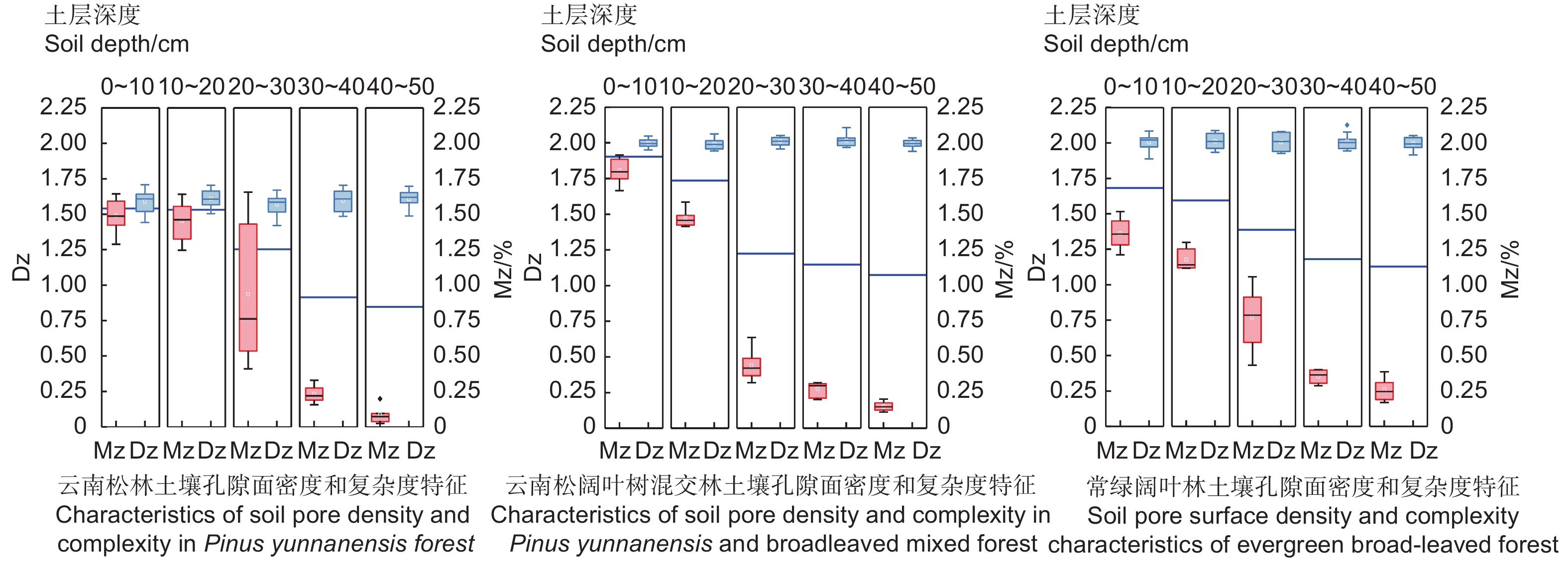
孔隙分形维数可表征大孔隙的分布特征,图1为3种林分土壤孔隙分形特征,由图知,土壤孔隙面密度(MZ)随土壤发生层加深而降低,不同林分变化规律有差异;土壤孔隙复杂度(Dz)随土层加深单调增大,云南松林(1.595)<云南松阔叶树混交林(2.003)<常绿阔叶林(2.006)。
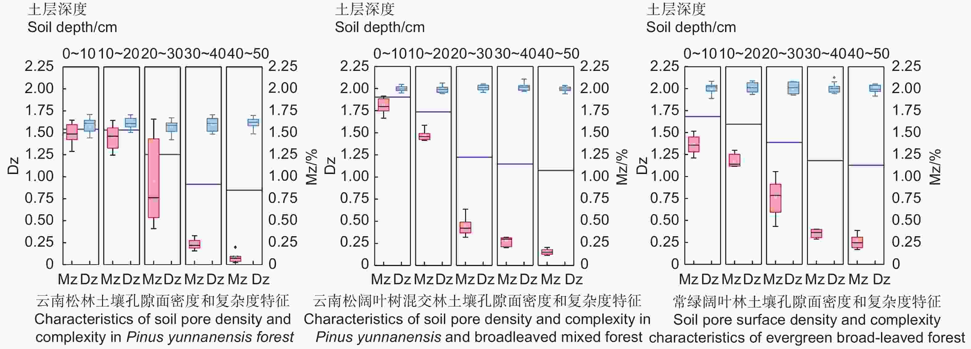
Figure 1. Changes of soil pore density and complexity with soil depth in three forest lands
0~20 cm土层深度内,不同演替阶段森林群落土壤面密度变化:PMF > PF > EF;20~30 cm孔隙面密度大小变化:PF > PMF > EF;而深层土壤中,3种林地中云南松林土壤孔隙面密度最小,表明3种林地内不同土层间孔隙变异程度不同。土壤孔隙复杂度变化规律与孔隙面密度相反,随土层深度增加递增。常绿阔叶林和云南松阔叶树混交林的Dz较云南松林大,表明常绿阔叶林和云南松阔叶树混交林土壤大孔隙扭曲度较大,孔隙形态更复杂,而云南松林Dz最小,大孔隙扭曲度小,孔隙结构单一。各土层之间孔隙复杂度变化有较大差异,0~20 cm和40~50 cm土层土壤孔隙复杂度为常绿阔叶林最大,云南松林最小;而20~40 cm土层,云南松林最低。
-
3种林地土壤各径级团聚体含量分布如图2,> 2 mm粒径的团聚体占有较大比重。0~50 cm内云南松林地其含量分别为:71.82%、66.20%、36.95%、21.09%和20.22%;云南松阔叶树混交林0~50 cm含量依次为:55.23%、50.47%、47.14 %、40.29%和34.94%;常绿阔叶林含量则为:53.24%、45.79%、31.67%、21.08%和14.11%。大粒径团聚体含量随土层中增加而减少,小粒径团聚体含量随土层变化正相反,> 2 mm、2.0~1.0 mm团聚体含量减小,而1.0~0.5 mm、0.5~0.25 mm和< 0.25 mm等小粒径的团聚体含量呈增加趋势;土层加深,各粒径团聚含量在局部上有显著差异(P < 0.05)。
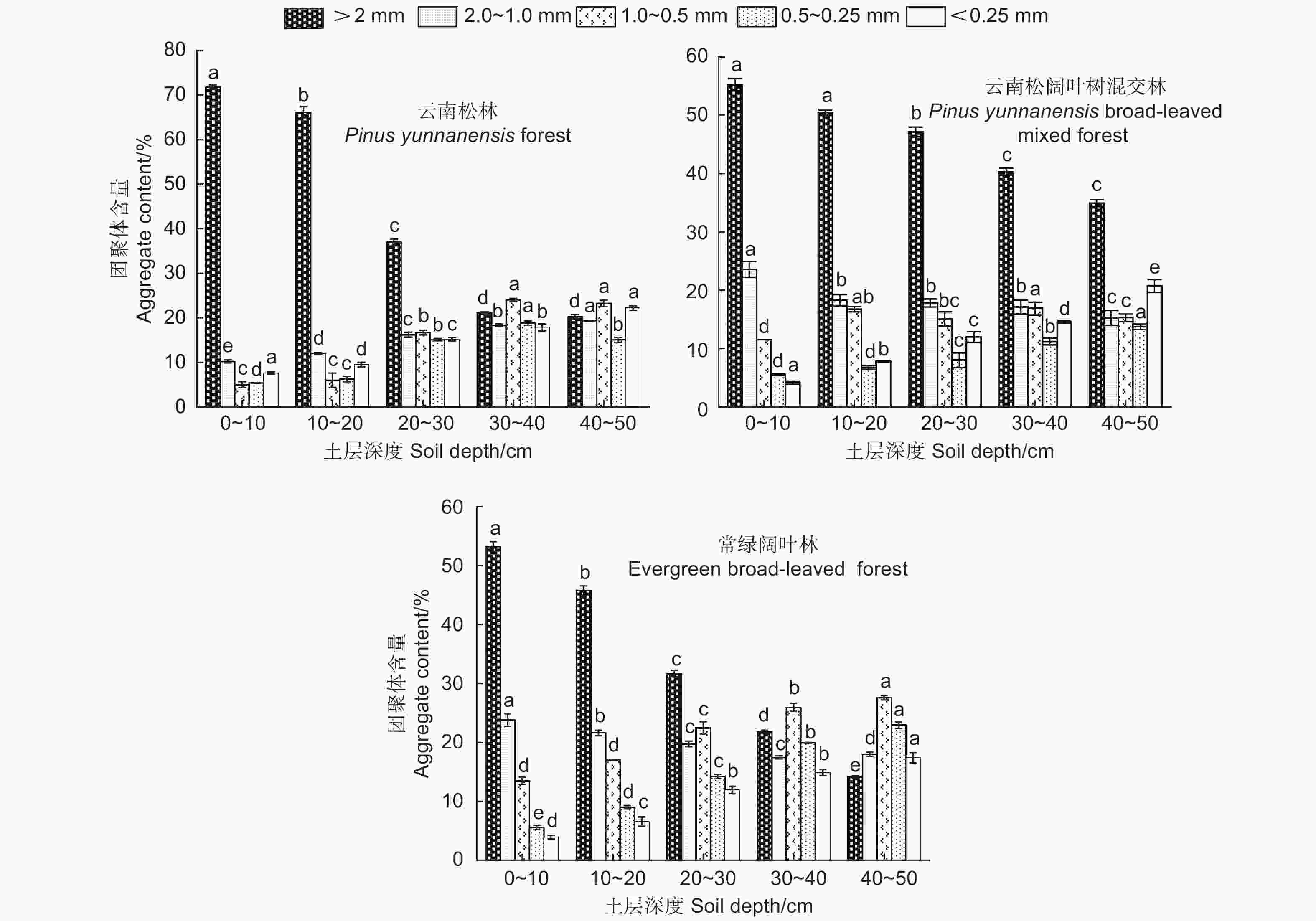
Figure 2. Distribution characteristics of soil water-stable aggregates in different soil layers of different woodlands
森林土壤长期处于自然状态,人为扰动小,土壤以大团聚体(> 0.25 mm)为主,云南松林地0~50 cm含量依次为92.38%、90.47%、84.87%、82.17%和77.74%,云南松阔叶树混交林地0~50 cm含量分别为:95.87%、92.17%、88.02%、85.47%和79.28%,常绿阔叶林0~50 cm含量分别为:96.07%、93.44%、88.07%、85.12%和82.59%,且部分土层各粒径团聚体含量有显著性变化(P < 0.05)。除常绿阔叶林30~40 cm外,其余土层大团聚体含量变化为常绿阔叶林>云南松阔叶树混交林>云南松林,30~40 cm其含量为云南松阔叶树混交林>常绿阔叶林>云南松林。
3种林地土壤团聚体分形维数及土壤结构稳定性特征见表3,团聚体分维值(D团)随土层增加而减小,且各不同土层间团聚体分形维数差异性显著(P < 0.05);土壤团聚体结构破坏率随土层深度增加单调递增,各土壤发生层PAD显著增加(P < 0.05),表明随土层增加,其结构稳定性减弱。据表3知,常绿阔叶林除30~40 cm外其余土层土壤团聚体分形维数值较另外两种林地小,表明其土壤团聚体结构稳定性最佳,且云南松林D团最大,其团聚体稳定性最差。
土层深度 Soil depth/cm PF-D团 PMF-D团 EF-D团 PF-PAD PMF-PAD EF-PAD 0~10 2.611 ± 0.003 a 2.609 ± 0.004 e 2.541 ± 0.002 a 1.436 ± 0.031 e 1.097 ± 0.003 e 1.199 ± 0.041 e 10~20 2.564 ± 0.011 b 2.570 ± 0.013 d 2.457 ± 0.006 b 1.950 ± 0.047 d 1.791 ± 0.003 d 1.960 ± 0.004 d 20~30 2.340 ± 0.018 c 2.338 ± 0.040 c 2.332 ± 0.014 c 6.835 ± 0.235 c 5.494 ± 0.145 c 2.647 ± 0.004 c 30~40 2.324 ± 0.023 d 2.218 ± 0.010 b 2.261 ± 0.003 d 9.756 ± 0.372 b 5.505 ± 0.581 b 4.933 ± 0.003 b 40~50 2.218 ± 0.004 d 2.368 ± 0.005 a 2.150 ± 0.012 e 11.077 ± .0291 a 9.372 ± 0.219 a 8.414 ± 0.007 a 注:表中数据表示为:“平均值 ± 标准差”;PF:云南松林;PMF:云南松阔叶树混交林;EF:常绿阔叶林;小写字母表示不同土层之间差异显著(P < 0.05);D团:土壤团聚体分形维数;PAD:土壤团聚体破坏率。
Note: The datein the table is expressed: “mean ± standard deviation”. PF:Pinus yunnanensis forest. PMF: Pinus yunnanensis-broadleaved mixed forest. EF: evergreen-broadleaved forest, the same below. The lowercase letters indicated significant differences among different soil layers (P < 0.05). Dgroup: fractal dimension of soil aggregates. PAD: Soil aggregate destruction rate.Table 3. Fractal dimension and structural stability of soil aggregates in three forest lands
土壤PAD在不同群落结构表现出较大差异,不同土层深度,云南松林其PAD值最大,常绿阔叶林20~50 cm土层,土壤团聚体结构PAD最小,0~20 cm云南松阔叶树混交林结构稳定性较好,其原因是林下灌丛植被和表层枯落物覆盖度较高,致使于0~20 cm其结构稳定性稍好。
-
由表4知,3种林地各个土壤发生层,粘粒和粉粒含量随土层加深而增加,砂粒含量减少;同一发生层,土壤质地以粉粒为主。据图3得,土壤机械组成分形维数与粘粒含量有显著正相关关系(P < 0.05),相关系数达0.646,与粉粒含量之间有正相关关系(P > 0.05),与砂粒含量之间呈显著负相关(P < 0.05),相关系数为−0.676。此外,由表4可得,随土层加深,土壤机械组成分形维数增加,表明其结构越不稳定;3种林地内,云南松林机械组成分形维数最大,0~50 cm内其分维值分别是云南松阔叶树混交林的1.032、1.025、1.008、1.012、0.999倍,常绿阔叶林的1.016、1.031、1.013、1.048、1.022倍,表明云南松混交林和常绿阔叶林地内各土层结构较云南松林好。
森林类型
Forest type土层深度 Soil depth 粘粒 Clay 粉粒 Silt 砂粒 Sand 土壤机械分形维数 Fractal dimension cm < 0.002 mm/% 0.002 mm~0.05 mm /% 0.05 mm~2 mm /% D机 PF 0~10 11.2 ± 0.52 Ae 65.98 ± 0.55 Ac 22.81 ± 0.08 Ca 2.731 ± 0.027 Ac 10~20 15.89 ± 0.30 Ad 76.63 ± 0.52 Aa 7.48 ± 0.82 Bb 2.740 ± 0.001 Ac 20~30 18.94 ± 0.13 Ac 76.70 ± 0.63 Aa 4.36 ± 0.76 Cc 2.748 ± 0.011 Ab 30~40 21.03 ± 0.37 Ab 74.97 ± 0.30 Ab 4.00 ± 0.67 Cc 2.754 ± 0.012 Ab 40~50 21.45 ± 0.27 Aa 74.13 ± 0.86 Ab 4.42 ± 0.13 Cc 2.760 ± 0.028 Aa PMF 0~10 6.42 ± 0.074 Cc 58.74 ± 0.453 Be 34.85 ± 0.53 Ba 2.645 ± 0.045 Cb 10~20 7.61 ± 0.091 Cc 69.37 ± 0.563 Bd 23.01 ± 0.47 Bb 2.672 ± 0.008 Bb 20~30 16.17 ± 0.375 Bb 64.74 ± 0.145 Cc 19.09 ± 0.23 Bc 2.725 ± 0.012 Aa 30~40 17.02 ± 0.572 Bbc 74.18 ± 0.184 Bb 8.8 ± 0.76 Bd 2.721 ± 0.047 Cb 40~50 18.4 ± 0.014 Ba 76.65 ± 0.202 Ba 6.95 ± 0.19 Be 2.761 ± 0.006 Cab EF 0~10 6.72 ± 0.071 Be 54.20 ± 0.036 Ce 39.08 ± 0.044 Aa 2.681 ± 0.015 Bc 10~20 8.62 ± 0.067 Bd 68.59 ± 0.075 Bb 22.78 ± 0.074 Ac 2.656 ± 0.013 Bd 20~30 12.63 ± 0.047 Cc 73.37 ± 0.015 Ba 14.01 ± 0.026 Ae 2.712 ± 0.041 Ab 30~40 11.45 ± 0.105 Cb 65.54 ± 0.038 Cc 23.01 ± 0.029 Ab 2.628 ± 0.015 Bb 40~50 19.16 ± 0.060 Ca 61.87 ± 0.095 Cd 18.97 ± 0.061 Ad 2.701 ± 0.061 Ba 注:表中数据表示为“平均值 ± 标准差”;大写字母表示不同样地间差异显著(P < 0.05);小写字母则表示不同土层间各组分含量显著性差异(P < 0.05)。
Note: The date “ ± ” in the table is expressed as “mean ± standard deviation”. Capital letters showed significant differences (P < 0.05). The lowercase letters indicate the significant difference of each component content in different soil layers(P < 0.05).Table 4. Soil texture and particle fractal characteristics of forest land

Figure 3. Correlation analysis between fractal dimension of macropores and soil fractal structure clustering
本研究选取土壤孔隙特征和土壤分形结构相关分析见图3,由图知,土壤孔隙面密度与土壤非毛管孔隙度、总孔隙度、> 2 mm团聚体含量和团聚体分形维数等之间具有极显著的正相关关系(P < 0.01),相关系数分别为0.807、0.696、0.813、0.846,其与粘粒含量、1.0~0.5 mm、< 0.25 mm和0.5~0.25 mm团聚体含量之间则呈极显著的负相关关系(P < 0.01),相关系数分别为−0.818、−0.760、−0.833、−0.782,与土壤毛管孔隙度和砂粒间呈显著的正相关关系(P < 0.05);土壤孔隙复杂度与土壤机械组成分形维数则有显著负相关关系(P < 0.05)。
土壤孔隙面密度与土壤中不同径级团聚体含量、机械组成和D团有显著的相关性(图3),本实验采用通径分析法进一步明确各因子对孔隙面密度的影响差异,结果显示(表5),1.0~0.5 mm团聚体含量对Mz的直接作用最大,其次是> 2 mm团聚体含量,直接效应系数分别为1.219和0.645,而粘粒含量0.5~0.25 mm径级团聚体含量则呈现负效应;分析影响因子的间接系数表明,< 0.25 mm团聚体的间接影响作用最大,其次为D团,间接作用系数为1.1727、0.6138,说明土壤结构中,细颗粒结构对孔隙结构影响较大,随着孔隙被细小颗粒填充,土壤结构孔隙通透性和渗透性减弱,孔隙面密度减少。
自变量
Independent variable与Y的相关系数
Correlation coefficient with Y直接作用系数
Direct acting coefficient间接作用系数/Indirect coefficient X1 X2 X3 X4 X5 X6 合计
TotalX1 −0.754 −0.597 — 0.1282 −0.3035 −0.0018 −0.0188 0.0394 −0.1565 X2 0.028 0.6045 −0.019 — −1.1593 0.8538 −0.2018 −0.0019 −0.5282 X3 0.121 1.219 0.1486 −0.3335 — −0.7994 0.1703 0.0052 −0.8088 X4 −0.252 −0.921 −0.0012 −0.6063 0.8362 — 0.2032 0.0151 0.447 X5 −0.198 0.232 0.0484 −0.5687 0.8947 0.7955 — 0.0028 1.1727 X6 0.354 0.074 0.3167 0.0161 0.0853 0.1869 0.0088 — 0.6138 注:表中Y:大孔隙面密度;X1:粘粒含量;X2、X3、X4、X5分别表示:> 2 mm、1.0~0.5 mm、0.5~0.25 mm和< 0.25 mm团聚体含量,X6:团聚体分形维数。
Note: Y: Macropore surface density; X1: Clay content. X2, X3, X4, X5 represent aggregate content of > 2 mm,1.0~0.5 mm, 0.5~0.25 mm and < 0.25 mm, X6 respectively: represent fractal dimension of aggregate.Table 5. Relationship between soil pore density and soil factors
-
简单群落向顶级群落演替进程中,不同林分类型之间,土壤大孔隙特征差异明显,土壤有机质和Mg2 + 、Fe3 + 等金属离子逐渐积累,土壤有效养分增加且趋于多元化[28],本研究中,3种森林群落孔隙数量和孔隙半径随土层的变化与陈晓冰[29]、邵一敏[30]等研究相同,土层越深,土体紧实,孔隙数量减少;孔隙半径越大,数量减少,但局部土层深度和孔隙半径内,孔隙数量变化有所差异,原因为大孔隙垂直分布规律与土层中根系含量相关[31],不同群落间,垂直剖面总孔隙度变化明显,局部土层(0~20 cm),云南松阔叶树混交林的TP较常绿阔叶林大,是由于云南松阔叶树混交林内,小乔木和灌丛覆盖度较高,丰富的根系网络为大孔隙的形成提供有利条件所致[32]。
染色实验获取的垂直染色剖面,不仅反映了土壤水分运动规律,还反映出大孔隙特性及孔隙面密度特征,孔隙数量越多,增强土壤的持水性[33],便于为群落植被提供水热条件。研究表明,各森林群落间土层加深,孔隙染色面积变小,Mz降低,土壤结构间的紧实度增加[34],不利于水源的蓄积,降低土壤蓄水固土生态功能。不同演替群落内,上层土壤因灌草覆盖改善土壤内部孔隙状况,云南松阔叶树混交林下土壤疏松度较好,而常绿阔叶林较混交林土壤结构稍紧实,这与王伟等[35]研究有差异;深层土壤则是常绿阔叶林孔隙特性最佳,该结论与Meng C[11]、Zhang Y[13]等研究一致,森林群落等级越高,种群结构越复杂,土壤内部产生的孔隙通透性越好,但剖面孔隙染色面积规律与刘目兴等[36]等对不同植被土壤类型的研究结论有出入,这与不同地域植被类型和土壤结构差异性有关。
孔隙复杂度的波动形态可反映垂直方向上孔隙的变异程度,结果显示,常绿阔叶林土壤孔隙变异程度相对较大,孔隙形态相对复杂,云南松林土壤孔隙形态较均匀,变异程度较小,原因是群落演替过程中,群落等级越高,林内树种结构复杂,根系网络发达,致使土壤孔隙复杂度变大。孔隙变异度随土层的变化与甘磊等[34]研究一致,土层越深,Dz越大,土壤内部孔隙状况越复杂,扭曲度越高,且常绿阔叶林地Dz更大,表明林种结构越复杂,土壤大孔隙的变异程度越高,分布形态越不均匀。
-
长期处于自然状态下的森林土壤以> 0.25 mm的团聚体为主,土层越深,团聚体含量同熊佰炼等研究相同,随土层中增加而减少[37],小粒径团聚体含量则随土层变化增加;常绿阔叶林30~40 cm大团聚体含量为云南松阔叶树混交林>常绿阔叶林>云南松林,原因为云南松阔叶树混交林内,林下覆有灌木丛和小乔木树种,根系的穿插作用改善孔隙通透性和团聚体特征[38]。其余土层顶级群落土壤大团聚体含量较高,土壤结构稳定性较其余两种林地好。
顶级群落常绿阔叶林D团最小,土壤结构越好。0~20 cm土层云南松阔叶树混交林PAD最小,而30~50 cm则是常绿阔叶林最小,表层枯落物堆积分解增加了土壤中的有机质和有效养分含量,提高土壤的水稳定性,改善土壤结构。机械组成分形维数越小土壤结构越好,该研究中,垂直剖面10~50 cm内D机均为:常绿阔叶林<云南松阔叶树混交林<云南松林,常绿阔叶林土壤结构最佳,云南松土壤结构最差,与Guo X[39]对不同树种林分土壤分形结构特征研究结论相同,0~10 cm出现异常可能是云南松阔叶树混交林根系网络和表层枯落物分解的共同作用,大量的腐殖质改善了土壤质地使D机变小。Liu X[23]研究显示,森林群落类型会影响大孔隙的小规模聚集,进而影响土壤持水能力,且土层越深土壤结构的蓄水能力变差,这与林立文等[37]、Yl A[40]等结论一致。不同演替的森林群落,同一土壤发生层,EF和PMF的土壤机械组成分形维数明显小于PF,群落在不断的演替过程中,林分复杂的森林群落,枯落物层较厚,分解增加土壤有机质含量,改变土壤物理性质,改善土壤孔隙结构,提高土壤结构稳定性。不同群落间土层越深,粘粒、粉粒含量减少,砂粒含量增加,土壤机械分形维数增加。顶级群落在长期的演替过程中,群落环境复杂,提高土壤养分,改善土壤结构。土壤理化性质及自身空间的异质性是影响土壤大孔隙的主要原因之一[41],相关性分析表明,Mz与D团呈现显著的相关性,与< 0.25 mm、0.25~1 mm的团聚体含量有极显著负相关关系,和甘磊等[35]研究结论相同;Dz与D机间呈负相关关系。
-
不同演替森林群落大孔隙特征变化差异明显,3种林分中,总孔隙度和孔隙面密度均随土层加深而减小,而孔隙复杂度则随之增大;土层越深,土粒结构间越紧密,孔隙特性越差。
土壤分形特征随土层增加有显著变化,3种不同演替阶段的森林群落,顶级群落土壤大孔隙变异程度最大,孔隙形态更复杂;由土壤D团、D机、土壤水稳定性和结构破坏率知,土层越深,土壤质量和结构越差,群落演替等级越高,总孔隙度和抗破坏率越高,结构越稳定。顶级群落土壤结构最佳,云南松林最差。
通径分析表明土壤孔隙特征与土壤理化因子关系密切,粘粒含量、砂粒含量、D团和各径级团聚体含量等是影响孔隙面密度的主要因子,而D机是导致孔隙复杂度变化的主要因素。
Effect of Fractal Characteristics of Soil Structure on Macropores in Different Succession Forest Communities in Mid-subtropical Region
- Received Date: 2021-08-05
- Accepted Date: 2021-12-05
- Available Online: 2022-04-20
Abstract:


 DownLoad: